
North Captiva Homes for Sale
North Captiva homes for sale are on a bridgeless barrier island in Lee County, between Captiva Pass and Redfish Pass, reached only by boat, ferry or a private airstrip. Listings often read "Captiva, FL 33924", and many say Upper Captiva, but North Captiva is its own island, separate from Captiva since the 1921 hurricane opened Redfish Pass. The Lee County Property Appraiser's 2026 roll counts 371 single-family homes and 280 vacant residential lots on North Captiva, plus 8 condominium units, and its sales file records 16 house sales at a $925,000 median in the 12 months to September 25, 2026. For Captiva Island itself, see Captiva Island homes for sale. Updated October 2026.
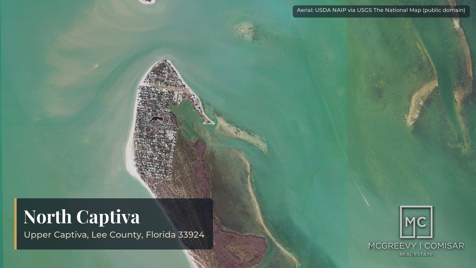
Buying here is different from buying on the mainland. Owners arrive by boat, move around by golf cart on sand roads, and rely on island water systems, wells and septic, a single fire and rescue district, and a barge for building materials. This page links current North Captiva listings, sets out the county's recorded sales and lot sales, names the neighborhoods and clubs with what each publishes, and covers taxes, insurance, the federal Coastal Barrier Resources System, flood zones, the storms that reshaped the island and what to check before you buy. Every figure names its record and date, and every source is listed at the bottom of the page.
By Jesse McGreevy and Marc Comisar, Domain Realty Group. Data updated: October 2026. Call Domain Realty Group at 239-441-2816.
Key takeaways for North Captiva buyers
- North Captiva (also called Upper Captiva) is a separate, bridgeless island between Captiva Pass and Redfish Pass in unincorporated Lee County, ZIP 33924; the 1921 hurricane split it from Captiva.
- The 2026 Lee County roll counts 371 single-family homes, 280 vacant residential lots and 8 condominium units on the island.
- Qualified county sales, 12 months to September 25, 2026: 16 houses at a $925,000 median ($420,000 to $2,900,000) and 7 lots at an $80,000 median; the 12 months before, 11 houses at $805,500.
- Membership in the Safety Harbor Club is mandatory for owners inside its development; the club publishes its rental, dock and $500 transfer fees but not its annual assessment.
- Property tax district 205 carries 14.6123 mills for 2026, including the Upper Captiva fire district's 3.75 mills, its charter cap.
- Effective flood maps (revised November 17, 2022) show Zones AE and VE across the island, and parts of North Captiva sit in the federal Coastal Barrier Resources System, which can rule out federal flood insurance for newer buildings: get a parcel determination.
- Hurricane Ian (2022) made landfall on neighboring Cayo Costa; Florida DEP counted 50 North Captiva homes with major damage.
- There is no bridge, no urgent care and no published barge price: access, water, septic, insurance and title are the checks to run before an offer.
North Captiva homes for sale right now
North Captiva homes for sale are listed in the MLS under the Captiva city name, so the searches below cover ZIP 33924, which also holds Captiva Island: check each listing's street and the words "North Captiva" or "Upper Captiva" in its description before comparing prices. Sort from the top or the bottom of the market, or open the land search for lots. Data updated: October 2026.
- All Captiva and North Captiva homes for sale, highest price first
- Captiva and North Captiva homes for sale, lowest price first
- Captiva and North Captiva lots and land for sale
Listing data refreshes from the MLS throughout the day, and a listing shown may already be under contract. Days on market, sale-to-list ratios, boat slip details and club fees by listing come from the MLS and the clubs, not the county record; the recorded sales below come from the Lee County Property Appraiser.
Ready to see North Captiva homes?
Tell us whether you want a Gulf-front home, a bay-side home with a dock, a home inside the Safety Harbor Club or a lot to build on, and your price range, and a Domain Realty Group agent will set up the boat trip and showings, pull the recorded sales on that street and gather the club rules, flood and insurance facts to check before you offer. Contact Domain Realty Group, call 239-441-2816, or search all Southwest Florida listings.
Where is North Captiva, and is it part of Captiva?
North Captiva is a separate, bridgeless barrier island in unincorporated Lee County, Florida, between Captiva Pass on the north and Redfish Pass on the south, and it is not part of Captiva Island, although both share ZIP 33924 and many listings label North Captiva homes as Captiva or Upper Captiva. Data updated: October 2026.
The Lee Property Appraiser's 2026 roll counts 842 parcels on the island, including 371 single-family homes and 280 vacant residential lots. The sections below use that roll and the Lee sales file (newest sale in the file: September 25, 2026) for every county figure.
What is North Captiva, and where is it?
The Florida Department of Environmental Protection (DEP) describes North Captiva as extending four miles between Captiva Pass and Redfish Pass. The Gulf of Mexico is on the west side and Pine Island Sound is on the east side. Cayo Costa lies across Captiva Pass to the north, and Captiva Island lies across Redfish Pass to the south.
There is no bridge and there are no public roads. Reaching the island takes a boat, a water taxi or a private aircraft, and the paths on the island are private sand and shell paths. The access details are on the access section of this page; this section is about where the island sits on the map and in the county record.
Is North Captiva part of Captiva Island?
No. Today it is a separate island. DEP's Redfish Pass Inlet Management Plan (September 2022) states that the hurricane of 1921 breached Captiva Island, forming Redfish Pass and separating North Captiva Island from Captiva Island. Before that storm, DEP says, Blind Pass, five miles to the south, was the larger inlet, and Redfish Pass has since stayed in about the same place.
The Florida Museum of Natural History (Randell Research Center) gives the width of the new pass as 4,127 feet in 1921 and 660 feet by 1977. The history of the split is told in the history section of this page.
The two islands are sold and searched separately. For homes on Captiva Island proper, see our Captiva Island homes for sale page. Everything on this page is about the island north of Redfish Pass.
Which ZIP code and which name does North Captiva use?
North Captiva shares ZIP 33924 with Captiva Island. A mailing address on the island can therefore read "Captiva, FL 33924," and listing sites use "Captiva," "Upper Captiva" and "North Captiva" for the same island. The county record uses both names too: the roll carries a subdivision called Upper Captiva Shores and another called North Captiva Dunes, the fire district is the Upper Captiva Fire Protection and Rescue Service District, and Lee County's Land Development Code has an Upper Captiva Community Plan Area (Chapter 33, Article XI, as titled on Municode).
Two practical points follow from the shared ZIP code:
- A search by ZIP 33924 returns both islands. Check the street name and the parcel record to see which island a property is on.
- Search both names. A listing titled "Upper Captiva" is on this island, not on Captiva Island.
Who governs North Captiva?
North Captiva is unincorporated Lee County. It has no city or town government, so Lee County sets the land development rules and issues the building permits. The Upper Captiva Fire Protection and Rescue Service District, created by Chapter 2004-470, Laws of Florida, is the one special district we found. No county MSTU, MSBU or community development district for the island turned up in the sources read; that is a negative finding, not a confirmed absence, and the Lee County special-district list would settle it.
Private associations also matter on the island. The Safety Harbor Club is a homeowners association and planned unit development, and membership is mandatory for anyone holding title inside it. The neighborhoods and clubs section covers each association, and the pre-purchase checklist below covers how to ask for the recorded declaration.
Where does the fire district boundary fall?
The fire district's own site describes its territory as all that part of North Captiva Island lying in Sections 4, 5, 8, 9, 15 and 16, Township 45 South, Range 21 East. The 2004 charter act describes parts of Townships 44 and 45 South, Range 21 East, and names Captiva Pass, the Gulf, Redfish Pass and Pine Island Sound as the water boundaries. The roll's parcels fall in these sections:
| Township and section | Parcels on the 2026 roll |
|---|---|
| T44S R21E, section 32 | 136 |
| T45S R21E, section 4 | 16 |
| T45S R21E, section 5 | 573 |
| T45S R21E, section 9 | 61 |
| T45S R21E, section 15 | 55 |
| T45S R21E, section 16 | 1 |
| Total | 842 |
Sources: Lee Property Appraiser 2026 roll file (20261025_LCPA_Parcel_Data_TXT), parcel counts by section code; Upper Captiva Fire Protection and Rescue Service District, About page; Chapter 2004-470, Laws of Florida (CS/HB 1717), read October 30, 2026.
Section 8 is on the district's list but holds no parcel on the roll, and section 32 of Township 44 South is on the roll but not on the district website's list. The charter act, not the website, carries the legal description, so a buyer who needs to know whether a specific parcel is inside the district should read the act and the parcel's legal description together. The district levies its own tax on every parcel inside it; the cost section of this page covers the rate.
How much of the island is state park land?
A large share of the island is state park land that private buyers cannot purchase, but this page prints no acreage because the sources disagree. Cayo Costa State Park occupies portions of four islands: Cayo Costa, Punta Blanca, North Captiva and Bokeelia Island, a total of 2,675.35 acres, first acquired September 7, 1976 (DEP draft unit management plan). The plan states that North Captiva and Punta Blanca contain no facilities or recreational infrastructure, and it targets the remaining unimproved private parcels on the central and southern island for acquisition.
The county roll lists 35 park or recreation parcels. The plan gives a whole-park total only, and secondary sources give conflicting North Captiva figures, so ask Lee County or the title agent for the parcel map of any lot near the central island.
What does the county roll list on North Captiva?
| Roll category | Parcels |
|---|---|
| Single-family homes | 371 |
| Vacant residential lots | 280 |
| Condominium units | 8 |
| Small multi-family parcels | 2 |
| Mobile home | 1 |
| Park or recreation parcels | 35 |
| Submerged parcels | 48 |
| Common elements and other uses | 97 (842 minus 745) |
| Total | 842 |
Sources: Lee Property Appraiser 2026 roll file (20261025_LCPA_Parcel_Data_TXT), parcels grouped by property use code, read October 28, 2026. The 745 is the sum of the first seven rows (371, 280, 8, 2, 1, 35 and 48).
The eight condominium units are in three small condominiums: Beach Villas of Upper Captiva (4 units at 640 Gulf Ln), Gulflane Condo (2 units on Gulf Ln) and Smithbrook Condo (2 units on Coral Cir). The county recorded no condominium sale in either of the last two 12-month windows.
These counts are larger than some older estimates. A 2004 DEP report quoted the fire department's figure of approximately 300 homes at the time of Hurricane Charley, and a 2022 DEP report called it "a couple hundred homes on its north end and a dozen at its south end." The roll is the current parcel count; the older figures describe the island at the time of those storms.
What do North Captiva homes and lots sell for?
North Captiva homes and lots recorded 23 qualified sales in the 12 months from September 26, 2025 to September 25, 2026: 16 houses at a $925,000 median (range $420,000 to $2,900,000) and 7 vacant lots at an $80,000 median (range $45,000 to $108,375), per the Lee Property Appraiser sales file. Data updated: October 2026.
We tracked every qualified sale on the Lee County Property Appraiser file for the 842 parcels in the fire district's charter sections to build the tables below.
Every figure below comes from the Lee Property Appraiser's 2026 roll and the Lee sales file, which runs through September 25, 2026. A median is always shown with its count (n), because on an island of this size a handful of sales can move a median.
What did houses and lots sell for in the last 12 months?
| Property type | 12 months to Sept. 25, 2026: sales (n) | Median | Range | Prior 12 months: sales (n) | Median | Range |
|---|---|---|---|---|---|---|
| Houses (single-family) | 16 | $925,000 | $420,000 to $2,900,000 | 11 | $805,500 | $565,000 to $1,695,000 |
| Vacant residential lots | 7 | $80,000 | $45,000 to $108,375 | 6 | $82,500 | $50,000 to $235,000 |
| Condominium units | 0 | none | none | 0 | none | none |
Sources: Lee Property Appraiser 2026 roll and Lee sales file, qualified sales only. Current window September 26, 2025 to September 25, 2026; prior window September 26, 2024 to September 25, 2025.
The current window holds 23 sales in total (16 houses and 7 lots). Eight of those 23 sales are on the North End Captiva Island plat, the largest platted area on the island.
Which North Captiva properties sold in the last 12 months?
The table lists each qualified sale in the current window by recorded date. "County roll year built" is the year in the county roll for that individual house; this page does not use the roll's building fields for any island-wide statistic.
| Sale date | Price | Type | Area | Street | County roll year built |
|---|---|---|---|---|---|
| Sept. 30, 2025 | $1,675,000 | House | Upper Captiva Shores | 12637 South Banks Dr | 1989 |
| Dec. 5, 2025 | $905,000 | House | Safety Harbor Club | 4441 Harbor Bend Dr | 2023 |
| Jan. 6, 2026 | $1,430,000 | House | North End Captiva Island plat | 551 Gulf Ln | 1986 |
| Jan. 12, 2026 | $60,000 | Lot | Punta Robalo | 150 Hummingbird Dr | not applicable |
| Jan. 21, 2026 | $108,375 | Lot | Parcel described by survey, north end bird streets (section 32) | 130 Swallow Dr | not applicable |
| Mar. 16, 2026 | $70,000 | Lot | North End Captiva Island plat | 570 Coral Cir | not applicable |
| Mar. 26, 2026 | $945,000 | House | Parcel described by survey (section 5) | 4591 Oro Pesos Ln | 1993 |
| Apr. 3, 2026 | $1,300,000 | House | Jose's Hideaway | 341 Spanish Gold Ln | 1983 |
| Apr. 6, 2026 | $2,900,000 | House | North End Captiva Island plat | 4600 Schooner Dr | 2008 |
| Apr. 14, 2026 | $95,000 | Lot | North End Captiva Island plat | 4431 Schooner Dr | not applicable |
| Apr. 27, 2026 | $420,000 | House | Jose's Hideaway | 310 Pieces of Eight | 1992 |
| Apr. 30, 2026 | $1,254,500 | House | North Captiva Dunes | 4470 Butterfly Shell Dr | 2022 |
| May 8, 2026 | $560,000 | House | Village at Safety Harbor | 4500 Escondido Ln 69 | 1985 |
| May 13, 2026 | $692,000 | House | Parcel described by survey, north end bird streets (section 32) | 211 White Pelican Dr | 1992 |
| June 2, 2026 | $45,000 | Lot | Jose's Hideaway | 4541 Oro Pesos Ln | not applicable |
| July 9, 2026 | $445,000 | House | Parcel described by survey, north end bird streets (section 32) | 211 White Pelican Dr | 1992 |
| July 10, 2026 | $1,381,500 | House | Parcel described by survey (section 5) | 631 Rum Rd | 2020 |
| July 13, 2026 | $653,000 | House | Jose's Hideaway | 4570 Escondido Ln | 1964 |
| July 16, 2026 | $892,000 | House | North End Captiva Island plat | 4481 Bartlett Pkwy | 1980 |
| Aug. 19, 2026 | $1,034,999 | House | Parcel described by survey (section 5) | 4501 Seair Ln | 2015 |
| Aug. 27, 2026 | $80,000 | Lot | North End Captiva Island plat | 4501 Schooner Dr | not applicable |
| Aug. 27, 2026 | $894,000 | House | North End Captiva Island plat | 4511 Schooner Dr | 2001 |
| Sept. 1, 2026 | $97,500 | Lot | North End Captiva Island plat | 4481 Smugglers Dr | not applicable |
Sources: Lee Property Appraiser sales file and 2026 roll, qualified sales September 26, 2025 to September 25, 2026; area from the roll's legal description; year built from the county roll for that parcel only.
One address appears twice. 211 White Pelican Dr recorded two qualified sales, May 13, 2026 at $692,000 and July 9, 2026 at $445,000, on two different deeds. Both are printed as recorded. The county record does not say why the price changed, so a reader should not treat the two as a trend or as a flip; the deeds and the title history of that parcel are the documents that would explain it.
Which areas recorded the sales?
| Area (roll legal description) | Qualified sales in the last 12 months |
|---|---|
| North End Captiva Island plat | 8 |
| Jose's Hideaway | 4 |
| Parcels described by survey, north end bird streets (section 32) | 3 |
| Parcels described by survey (section 5) | 3 |
| Punta Robalo | 1 |
| Village at Safety Harbor | 1 |
| Safety Harbor Club | 1 |
| North Captiva Dunes | 1 |
| Upper Captiva Shores | 1 |
| Total | 23 |
Sources: Lee Property Appraiser sales file and 2026 roll, qualified sales September 26, 2025 to September 25, 2026; counts tallied from the sales table above.
Most areas recorded one to four sales, so this page prints no area median. A median of one sale is just that sale, and the neighborhoods section gives each area's parcel counts instead. "Parcels described by survey" are parcels whose legal description is a survey rather than a plat; they are not a neighborhood.
How have North Captiva sale prices moved by calendar year, 2015 to 2026?
The table gives the county's qualified sales by calendar year. "Homes" are houses and condominium units together; "lots" are vacant residential lots. The 2026 row is a partial year, running only to September 25, 2026, so its count is not comparable to a full year.
| Year | Home sales (n) | Home median | Lot sales (n) | Lot median |
|---|---|---|---|---|
| 2015 | 28 | $416,750 | 18 | $59,500 |
| 2016 | 30 | $486,250 | 8 | $225,000 |
| 2017 | 41 | $418,000 | 11 | $85,000 |
| 2018 | 19 | $450,000 | 14 | $82,500 |
| 2019 | 26 | $500,000 | 13 | $76,326 |
| 2020 | 57 | $369,000 | 30 | $67,000 |
| 2021 | 72 | $715,750 | 46 | $144,000 |
| 2022 | 28 | $775,000 | 37 | $165,000 |
| 2023 | 11 | $900,000 | 18 | $143,750 |
| 2024 | 18 | $951,000 | 6 | $139,500 |
| 2025 | 9 | $905,000 | 5 | $85,000 |
| 2026 (to Sept. 25, partial year) | 14 | $919,500 | 7 | $80,000 |
Sources: Lee Property Appraiser 2026 roll and Lee sales file, qualified sales by calendar year; 2026 runs to September 25, 2026.
Three facts stand out in the record without needing interpretation:
- The count of recorded home sales peaked at 72 in 2021 and was 9 in 2025. The 2026 count of 14 covers about nine months.
- The home median was $369,000 (n = 57) in 2020 and $951,000 (n = 18) in 2024.
- The lot median was $165,000 (n = 37) in 2022 and $80,000 (n = 7) in 2026 to date.
The record does not say why. Sale counts reflect what owners listed and what buyers bought, not what was available, so a low count is not a measure of demand.
What can the county record not show about a North Captiva sale?
The county sales file records a recorded price, a date and a qualification code. It does not record several things that decide what a given property is worth to a buyer:
- List prices and price changes. The file holds closed prices only, not what a property was offered at.
- Days on market. Nothing in the deed shows how long a property was for sale.
- Boat slips and docks. Whether a sale included a deeded or assigned slip, a private dock or a club membership is not in the roll.
- Gulf or bay frontage. The roll's legal description gives a plat or survey, not whether a lot fronts the Gulf, Pine Island Sound or an interior canal.
- Cash or financed purchases. The county record does not say how a sale was paid for.
- Furnishings, rental history and condition. A recorded price may include furniture, equipment or a rental business.
- Flood zone, elevation and CBRS status. These are parcel-level facts held by FEMA and the U.S. Fish and Wildlife Service, covered in the lot-buying and checklist sections below.
For those items, the listing agent, the seller's disclosures, the title commitment and an elevation certificate are the documents that settle them. The pre-purchase checklist on this page names each one.
How should a reader use these medians?
Use the medians as a record of what closed, with their counts beside them. A $925,000 median across 16 houses mixes a $420,000 house on Pieces of Eight with a $2,900,000 house on Schooner Dr. The range is the most honest summary of that spread. A reader pricing a specific property should compare it with the individual sales in the table above, by area, and with the sale dates, rather than with a single island-wide number.
Which neighborhoods and clubs are on North Captiva?
North Captiva has nine named areas on the Lee County roll, led by the North End Captiva Island plat (73 homes, 80 lots), Jose's Hideaway (55 homes, 41 lots) and North Captiva Dunes (44 homes, 46 lots), plus two private clubs, the Safety Harbor Club and the North Captiva Island Club. Data updated: October 2026.
The counts below come from the Lee County Property Appraiser 2026 roll (parcel file 20261025_LCPA_Parcel_Data_TXT), measured by our team. "Homes" means parcels with a single-family use code; "lots" means vacant residential parcels. The roll lists 842 parcels on the island in all: 371 single-family homes, 280 vacant residential lots, 8 condominium units, 2 small multi-family parcels, 1 mobile home, 35 park or recreation parcels, 48 submerged parcels, and the rest common elements and other uses. Sales are qualified sales from the Lee sales file for the 12 months September 26, 2025 to September 25, 2026, the newest sale in that file.
How many homes and lots are in each North Captiva area?
| Area (county roll name) | Single-family homes | Vacant residential lots | Qualified sales, 12 months to Sept. 25, 2026 |
|---|---|---|---|
| North End Captiva Island plat | 73 | 80 | 8 (4 houses, 4 lots) |
| Jose's Hideaway | 55 | 41 | 4 (3 houses, 1 lot) |
| North Captiva Dunes | 44 | 46 | 1 (1 house) |
| Safety Harbor Club | 42 | 10 | 1 (1 house) |
| Village at Safety Harbor | 32 | 0 | 1 (1 house) |
| North-end bird streets, near the North Airstrip (includes North Captiva Sands and Punta Robalo) | 62 | 57 | 4 (2 houses, 2 lots) |
| Upper Captiva Shores (South Banks Dr) | 11 | 2 | 1 (1 house) |
| Redfish Shores (Foster Bay Dr) | 2 | 14 | 0 |
| Parcels described by survey rather than a plat | 50 | 30 | 3 (3 houses) |
| All areas | 371 | 280 | 23 (16 houses, 7 lots) |
Sources: Lee County Property Appraiser 2026 roll (file 20261025_LCPA_Parcel_Data_TXT) and the Lee sales file, newest sale September 25, 2026, measured by our team, October 2026. The 12-month house count of 16 and lot count of 7 add up from the rows above; no condominium sold in the window.
Only the 23 qualified sales are counted here, and a single sale says little about an area. Each sale is listed by date, price and street in the sales table in the pricing section of this page.
What is the North End Captiva Island plat?
The North End Captiva Island plat is the largest named area on the roll, with 182 parcels: 73 single-family homes and 80 vacant residential lots, plus a restaurant parcel, a park or recreation parcel and smaller uses. Its addresses sit on Schooner Dr, Bartlett Pkwy, Gulf Ln and Coral Cir. Eight of the 23 qualified sales in the last 12 months were on this plat, more than any other area.
The prices on this plat span the whole island range: a $70,000 lot on Coral Cir (March 16, 2026) and a $2,900,000 house on Schooner Dr (April 6, 2026), the highest price in the 12-month window. The state's park management plan says the north shoreline of the island moved east 250 feet to more than 1,500 feet over about 30 years (Florida DEP draft Cayo Costa State Park chapter, 2025), so the Gulf shoreline at the north end is not where older plats drew it. A property-level survey and an elevation certificate show where a given parcel sits today.
No readable recorded plat was found for this area, and no association is confirmed for it. The recorded declaration of covenants and the plat in the Lee County Clerk's records hold the answer.
What is Jose's Hideaway?
Jose's Hideaway has 124 parcels on the county roll: 55 single-family homes, 41 vacant residential lots and a handful of other uses. Four qualified sales closed in the 12 months to September 25, 2026: three houses ($420,000, $653,000 and $1,300,000) and one lot ($45,000, the lowest price in the window). Streets include Oro Pesos Ln, Spanish Gold Ln, Pieces of Eight and Escondido Ln.
Where it sits is not settled by a first-party source. Listings place it in the central part of the island near the harbor and ferry landing, but that comes from marketing text, not a plat. Whether Jose's Hideaway has a mandatory homeowners association is also unconfirmed; one neighborhood-profile site reports none on record, which is an algorithmic statement, not a recorded document. Ask the title company for the recorded declaration before assuming either way.
What is North Captiva Dunes?
North Captiva Dunes has 92 parcels on the roll: 44 single-family homes and 46 vacant residential lots, the only area where lots outnumber homes by more than a few. One house sold there in the 12 months to September 25, 2026, at $1,254,500 on April 30, 2026. Which side of the island the plat sits on is not stated by any source read, and no association status was confirmed.
What are the Safety Harbor Club and the Village at Safety Harbor?
The Safety Harbor Club is a private community on the bay side at Safety Harbor, with 53 parcels on the roll (42 single-family homes and 10 vacant residential lots). The Village at Safety Harbor is a separate roll plat with 34 parcels (32 single-family homes). The club describes itself as a private 30-acre community; its own address is 1 Harbor Bend Drive, Upper Captiva, FL 33924. One Safety Harbor Club house sold in the 12-month window ($905,000, December 5, 2025) and one Village house ($560,000, May 8, 2026).
The club's site describes 33 townhomes, 42 single-family homes and 12 vacant lots. The county roll shows 42 homes and 10 lots on the Safety Harbor Club plat and 32 homes on the Village plat. These are two different records with different boundaries, and this page does not reconcile them. Whether the Village at Safety Harbor townhomes fall inside the club's planned unit development is not stated in any document we read.
What are the north-end bird streets, North Captiva Sands and Punta Robalo?
Near the North Airstrip, a group of streets named for birds (Kingfisher, Swallow, Hummingbird, Mourning Dove, White Pelican, Pink Flamingo, Nighthawk and Goldfinch) holds 62 single-family homes and 57 vacant residential lots on the roll. Two plat names inside that group carry their own counts: North Captiva Sands (12 homes, 19 lots) and Punta Robalo (17 homes, 12 lots). The other parcels on those streets, 33 homes and 26 lots, are described by survey rather than a plat name.
Four qualified sales fell in this group in the last 12 months: a $60,000 lot on Hummingbird Dr (January 12, 2026), a $108,375 lot on Swallow Dr (January 21, 2026) and two sales of the same house at 211 White Pelican Dr. That house recorded two qualified sales on two different deeds, $692,000 on May 13, 2026 and $445,000 on July 9, 2026. Both are printed as recorded; the county file does not explain the difference between them.
What are Redfish Shores and Upper Captiva Shores on the south end?
Redfish Shores is the Gulf side of the narrower south end of the island, next to Redfish Pass (Florida DEP draft Cayo Costa chapter). The roll shows 56 parcels there, but 35 are submerged land: only 2 single-family homes and 14 vacant residential lots. The state plan says this area "experiences frequent erosion" and has mangroves exposed to Gulf wave energy. No sale was recorded there in the 12-month window.
Upper Captiva Shores, with South Banks Dr addresses, has 53 parcels, of which 25 are park or recreation land, 10 are submerged, 11 are single-family homes and 2 are vacant lots. One house on South Banks Dr sold on September 30, 2025 for $1,675,000. No source we read places this area on the map, so treat its location as unverified and get a survey. For flood, erosion and the Coastal Barrier Resources System status of the south end, see the flood section of this page.
What are the parcels described by survey rather than a plat?
Fifty single-family homes and 30 vacant residential lots on the roll sit in sections 4 and 5 under metes-and-bounds legal descriptions, not under a named plat. They are not a neighborhood. Three houses sold in the last 12 months within this group: $945,000 on Oro Pesos Ln (March 26, 2026), $1,381,500 on Rum Rd (July 10, 2026) and $1,034,999 on Seair Ln (August 19, 2026). Because there is no plat, the access easements, setback rules and any association covenants have to be found in the individual deeds and surveys.
Are there condominiums on North Captiva?
Yes, three small ones: 8 condominium units on the roll in total. Beach Villas of Upper Captiva has 4 units at 640 Gulf Ln, Gulflane Condo has 2 units on Gulf Ln and Smithbrook Condo has 2 units on Coral Cir. No condominium sold in the 12 months to September 25, 2026. For a condominium, the declaration, budget, reserve study and any special assessments are the documents to request; none of them is public in the sources we read.
Is Safety Harbor Club membership mandatory, and what does the club publish?
Yes, for anyone who holds title inside the club's planned unit development. The club's own Rules and Regulations (dated June 2025) define a member as any person who holds title to a lot or parcel within the club. There are 87 Class A memberships, which belong to owners inside the planned unit development. There are 43 Class C memberships, which are open to owners outside it, carry no vote and give use, not ownership, of the common elements. Data updated: October 2026.
| Item | What the club's June 2025 rules say |
|---|---|
| Who must belong | Anyone holding title inside the planned unit development (Class A, 87 memberships) |
| Who may join | Owners outside it (Class C, 43 memberships, non-voting) |
| Transfer fee | $500 on every ownership transfer; 30 days' notice before closing |
| Assessments | Billed quarterly in advance (December, March, June, September); the annual amount is not published in the rules |
| Assessment increases | Increases over 15 percent need a member vote |
| Late payment | 18 percent interest; at 60 days delinquent the club may suspend water, dockage, pool and tennis |
| Temporary membership fee, rentals under 60 days | $25 a day (Class A), $15 a day (Class C) |
| Rentals over 60 days | $1.50 a day |
| Renter's boat at club docks | $50 a day extra |
| Carts | Electric only; no internal-combustion carts from January 1, 2024 |
| Review of new building | Building Review Committee approves plans, exterior changes and landscaping before work starts |
Sources: Safety Harbor Club, Rules and Regulations, dated June 2025 (club website; the file carries an older internal title date, so confirm current figures with the club office); Safety Harbor Club website, read October 30, 2026.
The annual assessment dollar amount is not published. The club's budget or an estoppel certificate from the club would hold it, and the title commitment should show any recorded lien rights. The club runs its own wells, wastewater plant and trash collection, so the assessment funds utility service as well as amenities. It describes itself as private: visitors must be property owners or registered guests, and renters and guests register with the club office before arrival.
What is the North Captiva Island Club, and is membership required?
The North Captiva Island Club is a resort and amenity club near the ferry dock with pools, a poolside restaurant called Mango's, a market and a rental program. Whether membership is required for any particular home or lot is not verified. Do not assume that any lot carries mandatory Island Club membership; the recorded declaration, the Island Club's budget and the title commitment are the documents that would say.
The club's site publishes social membership options, and owners get the current terms and fees from the club itself. We do not print fee figures here because the pages that showed them could not be read in full and carried no date. One practical note: a second membership, a voluntary private airstrip association, also exists on the island and is covered in the next section.
What should you ask about any area before you buy?
- The recorded declaration of covenants for the plat, and whether an association collects assessments.
- For a Safety Harbor Club property, the current annual assessment, any special assessments and the transfer fee.
- For any area, the title commitment, because several plats have no readable recorded copy in public sources.
- A survey showing the parcel against the Gulf shoreline and any state-owned land.
Sources: Safety Harbor Club Rules and Regulations (June 2025); Lee County Property Appraiser 2026 roll; Florida DEP draft Cayo Costa State Park management plan chapter (2025).
How do you get to North Captiva without a bridge?
You reach North Captiva only by water or air, because the island has no bridge: by scheduled boat from Pineland Marina in Bokeelia on Pine Island, by your own boat, or by a private grass airstrip, and once there you move by electric golf cart, bicycle or on foot. Data updated: October 2026.
Every figure below was read from the named operator or agency on October 30, 2026 unless the text says otherwise. Where an operator has not published a fact, the text says so and names the document that would hold it.
What scheduled boats run to North Captiva?
The one passenger operator whose schedule and fares this page could read first-hand is Island Girl Charters, whose home port is Pineland Marina (Safe Harbor), 13921 Waterfront Drive, Bokeelia, FL 33922, on the north end of Pine Island. The operator's own site lists North Captiva (the Safety Harbor Club and the Mainstay restaurant) and Cabbage Key as its island destinations.
| Item | What the operator publishes (read October 30, 2026) |
|---|---|
| Round-trip fare, adult | $59.00 |
| Round-trip fare, child (11 and under) | $54.00 |
| Scheduled trips | "Six scheduled trips run daily" |
| Parking at Pineland Marina | $11.00 per calendar day; the operator asks arrivals after 5:00 p.m. to arrange parking in advance |
| Private or off-schedule trip | From $295.00 one way |
| Allowance for variations | "Allow up to 3 hours" in your plans |
| Luggage | One suitcase and one carry-on per person; coolers of 65 quarts or smaller |
| Groceries | Must be "boat packed" (paper bags inside plastic or reusable bags; wine and liquor may go in boxes) |
| Changes and cancellations | Up to 24 hours before departure, or the ride is charged |
Sources: Island Girl Charters home page, schedule page and FAQ, read October 30, 2026. The home page footer is dated 2013, so the date the fare table was last updated is not published; confirm the fare when you book.
The schedule page lists two patterns. From mid-October through July it prints 18 departure times (7:00, 7:30, 8:00, 9:00, 9:30, 10:00, 11:00, 11:15, 11:30, 1:00, 1:15, 1:30, 3:00, 3:30, 4:00, 5:00, 5:30 and 6:00) without assigning each to a direction. For August through October, Monday to Friday, it prints a paired table:
| Leaves Pineland Marina | Leaves North Captiva |
|---|---|
| 7:00 | 7:30 |
| 9:00 | 9:30 |
| 11:00 | 11:30 |
| 1:00 | 1:30 |
| 3:00 | 3:30 |
| 5:00 | 5:30 |
Sources: Island Girl Charters schedule page, read October 30, 2026. The page layout does not make the weekend times unambiguous, and it lists holiday boats (Thanksgiving Day at 9:00, 11:00, 1:00 and 3:00; Christmas Eve at 7:00, 9:00, 11:00, 1:00 and 3:00; Christmas Day closed). Treat the operator's current schedule as the only schedule.
Other operators exist but could not be verified. Visitor and rental listings name a ferry run by the North Captiva Island Club and a water taxi called Boats & Fun, both from the Pine Island side; the Island Club's site refused the fetch used for this page, so no timetable or fare is printed for either. Captiva Cruises has advertised a seasonal Thursday cruise from McCarthy's Marina on Captiva to North Captiva, but it is an excursion, the year on the notice is not shown, and it is not a commuter service. No scheduled service from Punta Gorda to North Captiva was found. The operator's current schedule is the document that settles any of these.
How long is the crossing, and where do you park?
No operator page read for this page publishes a fixed crossing time to North Captiva. Island Girl tells riders to allow up to three hours for variations, which is a planning margin, not a ride length. Secondary guides quote 20 to 30 minutes by ferry; that figure is unverified and is not used here. Pineland Marina is the parking point for the Island Girl boats, at $11.00 per calendar day as published.
To get to Bokeelia by road, Useppa Island Club's directions for its own Bokeelia marina (a different marina on the same part of Pine Island) run from the Veterans Parkway and SR 78 junction about 19 miles, then 5.4 miles to the four-way stop on Pine Island, then about 8 miles on Stringfellow Road, roughly 31 to 32 miles in all from that junction. Use them only as a guide to the Pine Island leg; Pineland Marina has its own address above. For homes on Pine Island itself, see Pine Island homes for sale.
Can you use your own boat?
Yes. North Captiva is bounded by Captiva Pass on the north, Redfish Pass on the south, the Gulf on the west and Pine Island Sound on the east, and any public ramp or marina on the sound can launch a boat for the crossing. Docking is the constraint, because the docks on the island are private. The Safety Harbor Club's own Rules and Regulations (June 2025) set these dock terms for members and guests:
- Dockage is first come, first served, with a T-dock for townhome owners.
- A boat moored by a non-member costs $50 a day extra.
- Temporary membership is $25 a day for Class A rentals and $15 a day for Class C for rentals under 60 days, and $1.50 a day over 60 days.
- Beam limits apply under the club's submerged land lease.
The North Captiva Island Club lists a marina and a floating ferry dock; its slip rates and rules are not verified here. No fuel dock was found in any source read: a 2016 cruising review said the island store had "no fuel or pump outs," and a post-Ian news headline reported residents struggling to get gas onto the island. Plan to fuel on the mainland and ask the seller or the clubs what is available now.
Whether a particular home comes with a slip, a dock right or a boat-lift permit is not in the county roll. It is in the recorded declaration, the club's slip assignment and the title commitment.
Is there an airstrip on North Captiva?
Yes, a private one. Aviation records list it as Salty Approach, FAA identifier FL90 (other records show different identifiers), a grass strip near the north end of the island. Published lengths disagree, from about 1,800 feet in the aviation record to about 2,000 feet (about 1,900 usable) in a Flying magazine report, so this page prints the range and no single number. It is a members-only private strip, as reported: use is limited to members of the company that runs it, and membership is separate from owning a lot. The county roll does not show airstrip rights.
Several streets near the north end carry bird names and sit beside the strip (the county roll groups them in the north-end bird streets). Whether a given parcel has airstrip frontage, a membership, or a recorded easement is a question for the recorded declaration, the strip operator's membership terms and the FAA airport record, none of which this page could read. No scheduled air service to the island was found.
How do groceries, fuel and building materials arrive?
- Passengers. One suitcase and one carry-on each, boat-packed groceries and coolers of 65 quarts or smaller on the Island Girl boats; larger items need the operator's office.
- Freight and construction. A 2022 Times of the Islands feature said supplies "must be brought in by shallow-draft barge," and the same barge service carries garbage off the island. No barge operator, landing point, capacity, schedule or rate sheet is published in any source read, so this page prints no barge price. A builder's quote and a Lee County building-permit submittal are the documents that name the logistics.
- Cost pressure. The Upper Captiva fire district's own FY2026-27 budget deck lists barging among its travel costs and cites higher barging cost after Hurricane Milton.
- Debris. After Milton, Lee County Solid Waste extended debris set-out for Cayo Costa and North Captiva to the end of December 2024 (county release of December 13, 2024).
- Propane and fuel. No supplier, delivery rule or storage rule was documented in the sources read. Ask the seller who supplies the home and how deliveries are made.
How do you get around on the island?
By electric golf cart, bicycle or on foot, on private sand and shell paths. The Florida Museum's Randell Research Center describes battery-powered golf carts on crushed shell and sand paths, and Visit Fort Myers (the Lee County tourism bureau) says no cars are allowed on the island. The Safety Harbor Club's own site states that combustion engine vehicles are prohibited for residents and visitors. Lee County's Upper Captiva land development provisions (Ordinance 14-13) address vehicles on pathways and beaches; the county's text was not readable for this page, so confirm the current provision.
The Safety Harbor Club's Rules and Regulations (June 2025) set these cart terms inside the club:
| Cart rule | Club rule |
|---|---|
| Power | Electric carts only; internal-combustion carts prohibited from January 1, 2024 (exceptions: Harbor Bend Drive between Bartlett and Escondido, and temporary construction use) |
| Operator | 16 or older with a valid license |
| Identification | Club decal with unit number |
| Speed and load | 10 mph maximum; 4 passengers maximum |
| Where not allowed | Beaches, undeveloped areas and docks |
Sources: Safety Harbor Club Rules and Regulations, June 2025 (the club's own PDF), pages 2 and 3.
The path network is private, so Florida's golf cart statute, section 316.212, which governs carts on county-designated roads, is background rather than the governing rule on the island. Rental listings mention stickers, a 15 mph limit and lighting rules for other parts of the island; none of those appears in a first-party document, so they are not repeated. Whether a cart conveys with a home is stated in the contract and any bill of sale.
What should you confirm about access before you buy?
- The operator's current schedule and fare for the season you will use the home, including the last boat of the day.
- Where you will park, and whether the lot is the operator's or the marina's.
- Any dock, slip or boat-lift right: the recorded declaration and title commitment.
- Airstrip membership terms, if the home borders the strip.
- Whether a cart, a boat or other equipment conveys, and who pays to move it.
- Barge access and cost for repairs or construction, from a contractor's quote.
For comparison, Captiva Island proper has a road and a bridge; see Captiva Island homes for sale.
Does North Captiva have power, water, sewer, internet and fire rescue?
North Captiva has electric service from Lee County Electric Cooperative, an island fire and EMS district with one station, wells and a septic or private-plant system instead of county water and sewer, a club-run trash and recycling service in one community, and no hospital or urgent care. What each home uses depends on its address. Data updated: October 2026.
The sections below are labeled by how well each fact is documented. Wherever a county or utility record is not published, the page says which document holds it. Confirm each service on the seller's disclosure, the permits and the utility bills for the address you are considering.
Who provides fire and EMS on North Captiva?
The Upper Captiva Fire Protection and Rescue Service District, an independent special district created by Chapter 2004-470, Laws of Florida (CS/HB 1717, approved June 17, 2004, replacing Chapter 90-397). Its own site (uppercaptivafire.org) lists fire suppression, EMS and rescue and fire prevention. The act sets out the district's boundaries as the part of North Captiva in specified sections of Townships 44 and 45 South, Range 21 East.
| Item | Published fact |
|---|---|
| Station | One station, 4511 Hodgepodge Lane, combination staffing (NERIS record FD12071523) |
| Governing board | Five commissioners elected by the district's qualified electors, four-year staggered terms |
| Tax cap in the act | 3.75 mills per year (section 6(2), Chapter 2004-470), except as Chapter 191 allows |
| Fire district levy | 3.75 mills in 2025 and 2026 (Lee Property Appraiser millage books) |
| FY2026-27 certified taxable value | $386,744,099, up $50.4 million or 15.0 percent from FY2026 (district resolutions and budget deck) |
| Homesteaded properties | 49, as the district's budget deck counts them from the Lee Property Appraiser in April 2026 |
| Apparatus | Engine 191, Engine 192, Brush 191, Tender 191 and Rescue 191; the district describes "no paved roads, bridges, or fire hydrants" |
| Fiscal year | October 1 to September 30 |
Sources: Upper Captiva Fire Protection and Rescue Service District About, Equipment and FAQ pages and FY2026-27 resolutions and budget deck, read October 30, 2026; Florida Senate enrolled text of CS/HB 1717 (2004); Lee Property Appraiser millage books for 2025 and 2026.
The district's FAQ answers the medical-access question directly. Call 911 for an emergency. The fire department provides EMS. Critical patients may be flown out by medical helicopter, weather permitting; lower-acuity patients go by fire department boat to Pineland Marina. The FAQ says "the island has no urgent care facility," and for minor medical issues you take a ferry to Pine Island or the Lee Co-op marina, then travel to an urgent care in Cape Coral. Open fires are allowed only in a constructed pit; the FAQ bars other burning, including on beaches.
Two points for a buyer to read in the district's own documents. First, the final FY2026-27 millage resolution (Resolution 2026-12, September 26, 2026) is handwritten and its scan was not readable for this page, so the adopted rate for the 2026 bill should be confirmed on the Lee County Tax Collector's notice. Second, the district has reported staffing turnover (a December 2022 news report described the chief and most members resigning, followed by an interim chief); the current Chief's Report and the budget deck show the present staffing. The ISO public protection class for the district was not published in any document read.
Is there electricity on North Captiva?
Yes. Lee County Electric Cooperative's own restoration notice of October 15, 2022 says "the harder hit sections of the Island, like North Captiva, will take time to rebuild," which confirms that LCEC serves the island. Commercial electric and phone service arrived in the 1980s, according to a 2022 Times of the Islands feature, which also reported that the lines do not reach about 11 southern homes, most of which run generators or solar. That is a 2022 magazine statement, not a utility map.
How power reaches the island (a submarine cable or another route), the cable's age and its capacity were not found in any LCEC document read. Ask the seller for twelve months of utility bills, which show the provider and the actual cost, and ask whether the home has a generator, a transfer switch and stored fuel. LCEC's territory map or restoration reports for Upper Captiva would be the document that settles the route.
Where does water come from?
From wells, not from a county water line. Two systems are documented. The Safety Harbor Club says its water runs through well houses monitored by the health department, along with its own wastewater plant and trash service, "similar to a local municipality" in the club's description. The Florida Department of Environmental Protection's source water assessment lists public water system 5364153, North Captiva Island Club Bath House WTP, 4451 Bartlett Pkwy, with one active well about 300 feet deep in the intermediate aquifer (2023 record).
Homes outside those systems are expected to use private wells or cisterns. Rental pages describe reverse-osmosis units and a sulfur taste; those are marketing statements and are not repeated as fact. No island water utility, water association or franchise was found, and none is confirmed either way for Island Water Association, which serves Sanibel and Captiva. Confirm on the seller's disclosure which source the home uses, the well permit, and the latest water test.
Is there sewer on North Captiva?
Not from Lee County. The Safety Harbor Club runs its own wastewater treatment plant. No county central sewer for North Captiva was found; a central sewer study we found concerns Captiva Island, not North Captiva. Every other home is expected to be on an on-site sewage treatment and disposal system (septic).
Florida requires a permit under section 381.0065 (2025 edition) before any septic system is constructed, repaired, modified, abandoned or operated; the statute's lot-size and density limits depend on whether the lot has a private well or a public water system (1,500 gallons per acre per day on private wells; 2,500 with public water). The 2025 edition is the one read here; confirm the current text, including any 2026 session-law change. The documents to ask for are the septic permit and its last inspection or pumping record. Whether a lot can still receive a new septic permit is a permitting question, not a market one.
What about trash and recycling?
The Safety Harbor Club provides garbage and trash removal, including recycling, to its members. Elsewhere, service is by private arrangement and barge. A 2002 Lee County agenda shows Upper Captiva among the "Outer Islands" proposed for a barge haul franchise rather than the county's mandatory collection program. A current county franchise, fee or assessment for North Captiva was not found. Ask the seller what the home pays and to whom.
What about internet and cell service?
No first-party provider list or coverage map for North Captiva was found. Internet and cellular coverage vary by location on an island with no cable plant documented, so do not assume a speed. The documents that answer it are the carriers' coverage maps and the FCC National Broadband Map entry for the address, and the seller's current bill. Check signal on the property before you rely on it for work or for security systems.
Who handles law enforcement and local governance?
North Captiva is unincorporated Lee County, so the Lee County Sheriff's Office has jurisdiction. Its Marine Unit has 19 boats and is "not staffed 24/7"; the sheriff's page tells callers to dial 911 for emergencies. No page naming an island deputy, substation or patrol schedule was found. The fire district is the only special district found for the island; no Lee County MSTU, MSBU or community development district was found, which is a negative result from searches, not a county list.
Private associations then add their own rules. The Safety Harbor Club is a homeowners association and planned unit development, and membership is mandatory for anyone holding title inside it (see the neighborhoods section). Other plats may have their own declarations; the recorded declaration in the Lee County Official Records is the document that says.
What should you ask the seller about services?
- Twelve months of electric, water, trash and internet bills.
- The well permit and water test, or the club account if the home is on the Safety Harbor Club system.
- The septic permit and last inspection or pumping record.
- Whether there is a generator, how it is fueled, and where propane or fuel comes from.
- Whether the home's tax bill shows the fire district line, and whether the property is homesteaded.
What is on North Captiva: restaurants, store, marinas, beaches and the park?
North Captiva has two restaurants reported open since 2024 (Mainstay and Mango's), a store reported at the Island Club, private club marinas, an airstrip for members and Gulf beaches, with a large state-owned part of the island in Cayo Costa State Park. Cars are not used; the Safety Harbor Club allows electric carts only. Data updated: October 2026.
Most of what operates is run by private clubs or small businesses, and none of the schedules below is published by Lee County. Treat every business as "confirm before you go," because hours changed after Hurricane Ian (2022) and the island has few sources that carry dates.
What restaurants are on North Captiva?
| Place | What is known | Dated source |
|---|---|---|
| Mainstay North Captiva Restaurant and Bar | Reopened in late summer 2024, almost two years after Hurricane Ian; one report says August, another September. Reached by boat into Safety Harbor. | Two 2024 news reports (Cape Captains; Yahoo, updated October 1, 2024) |
| Mango's North Captiva | Poolside restaurant at the Island Club; a reopening date is not stated. | Cape Captains, 2024 |
| Over the Waterfront | Restaurant of the Safety Harbor Club; the club's rules and site list it. Public access and hours are not confirmed, and a 2022 magazine article calls it private. | Safety Harbor Club site and rules (June 2025) |
| Boathouse Restaurant | Not in use since Hurricane Ian; the building was damaged by fire on November 27, 2023. | Yahoo News, November 27, 2023 |
Sources: Cape Captains (2024); Yahoo News (November 2023 and October 2024); Safety Harbor Club website and Rules and Regulations (June 2025); Times of the Islands (May 10, 2022). Hours are not published in any source we could date.
Is there a store or fuel on North Captiva?
A small store has been reported. In November 2023 the Island Club's market operated in an orange building by the floating ferry dock, and the Safety Harbor Club site lists a Safety Harbor Club Store. Mainstay is described as having a general store and ice cream counter. Stock and hours are not published.
No fuel dock was found. A 2016 cruising review said the island store had "no fuel or pump outs," and a news story title after Hurricane Ian described residents struggling to get gas onto the island. Treat fuel for boats and carts as something you bring from the mainland unless a club confirms otherwise. Groceries and building supplies reach the island by boat or barge; no barge operator or price is published.
What marinas and docks are on North Captiva?
Two dock systems are documented. The Safety Harbor Club's private wharf and docks are the better described: members, tenants and guests use them first come, first served; boats over 25 feet go along the main wharf perimeter, bulkhead interior and T-dock face; a beam over 10 feet is limited to certain sections under the club's submerged land lease; overnight stays need proof of insurance and registration. The rules do not give a slip count.
The Island Club appears in a marina directory as a marina near its ferry dock, with no depth or fuel data. A third site, Mainstay, offers dockside access on the channel. Slips, depths and any dock rights tied to a property are not on the county roll; ask for the slip assignment document and the submerged land lease in the title package. Island Girl Charters, the passenger ferry operator whose published schedule we verified (operator website, read October 30, 2026), names the Safety Harbor Club and Mainstay as its North Captiva stops.
Is there an airstrip on North Captiva?
Yes, a private grass strip listed under the FAA-style identifier FL90, called Salty Approach, at the north end. It is a members-only private strip, as reported by Flying magazine and aviation records. Its length is given as about 1,800 feet in one record and about 2,000 feet in another. Because the sources disagree and no first-party Salty Approach page was found, the recorded declaration or the FAA airport record is the document to check. The Lee County roll carries one golf, airstrip or recreation parcel on the island.
For buyers: the strip is not public, membership is a separate private arrangement and owning a home does not by itself mean airstrip access. We do not print a member count.
What are the beaches like?
The Gulf side has the dune beach. The state plan describes the north shoreline moving east 250 feet to more than 1,500 feet over about 30 years while the south half gained more than 300 feet of beach and dune. Safety Harbor Club members reach the Gulf by footpaths over the dunes; the club's beachfront gazebo was destroyed by Hurricane Milton (2024) and the club's site says it plans to rebuild it (page undated). Club members cannot take carts onto the beaches. On state land, park policy is no beach raking, so the wrack line stays.
The Florida DEP's June 2026 critically eroded beaches report rates the shoreline unevenly: R66 to R71 critically eroded, R71 to R78 non-critical, R79 to R82.3 critically eroded. A buyer comparing a Gulf lot with a bay lot should read that report and the erosion section of this page. We found no source on shelling conditions on North Captiva beaches, so none is stated.
What is the state park land on North Captiva?
Cayo Costa State Park covers parts of four islands (Cayo Costa, Punta Blanca, North Captiva and Bokeelia Island), 2,675.35 acres in total, first acquired on September 7, 1976, according to the state's draft unit management plan. The North Captiva portion has no facilities or recreational infrastructure; the park's visitor facilities are on Cayo Costa. This page prints no North Captiva acreage because published estimates conflict and the state's plan gives only the whole-park total.
For buyers: the plan's optimum boundary targets "remaining unimproved private parcels on the central and southern portions" of North Captiva that touch the existing park, and the plan lists North Captiva inholdings. That is a planning boundary, not an offer to buy any parcel. On the roll, 35 parcels carry a park or recreation use.
What is the Pine Island Sound Aquatic Preserve?
The bay side of North Captiva lies in the Pine Island Sound Aquatic Preserve, established in 1970 and listed by the state as 58,500 acres, more than 18 miles long and 4 to 5 miles wide. It holds seagrass, mangrove islands and an Outstanding Florida Waterbody designation, and the state notes manatees and bottlenose dolphins. Damaging seagrass can bring a fine of up to $1,000. Bay-side docks sit over state submerged land (the Safety Harbor Club's dock rules cite a Submerged Land Lease), so ask what lease or permit covers any dock a seller says conveys. The park plan also records manatees at Safety Harbor.
What are the sea turtle nesting and lighting rules?
Sea turtles nest on the island's Gulf beaches, and Lee County regulates lighting visible from the beach under Chapter 14, Article II, Division 2 of its Land Development Code (listed on the Florida Fish and Wildlife Conservation Commission ordinance page). The restricted season is reported as May 1 to October 31 in a Captiva-area document; confirm the current code with Lee County, because an amendment to align it with the state model ordinance was proposed and its adoption is not confirmed.
- Lee County's 2025 survey length: 81.6 km. FWC counted 2,381 loggerhead and 84 green turtle nests in Lee County that year (FWC statewide nesting totals, 2025).
- Loggerhead nests on Cayo Costa and North Captiva combined: 542 (2023), 657 (2024) and 623 (2025) (park plan).
- The Sanibel-Captiva Conservation Foundation counted 889 nests (868 loggerhead, 21 green) on Sanibel and Captiva in 2025; that count does not include North Captiva.
- A by-beach North Captiva nest figure was not found in a primary source.
Sources: FWC statewide nesting survey (2025 totals); SCCF, December 2, 2025; Florida DEP draft Cayo Costa chapter; FWC local lighting ordinance page; Lee County sea turtle page; Captiva Erosion Prevention District restriction document (2014, as reported).
What wildlife and water-quality notes matter to a buyer?
Shorebird nesting, gopher tortoises and red tide can affect how a parcel is cleared, lit and used. The U.S. Fish and Wildlife Service designated parts of Cayo Costa and North Captiva as critical habitat for wintering shorebirds on July 10, 2001. Lee County says its beaches host beach-nesting birds from April 1 through August 31. Gopher tortoises are regulated by the state wildlife agency, not Lee County, and a permit and an authorized agent are needed before any capture or relocation on a building site. A lot with burrows needs that check before clearing; no island-wide tortoise survey was found.
For red tide, the FWC Southwest Coast report of October 23, 2026 listed a station named "North Captiva; 14 mi W of USF": one surface sample Not Present and one 14-meter sample at background (0 to 1,000 cells per liter, no effects anticipated), collected October 15, 2026. That is a one-week snapshot, not a history.
The ferry and your own boat reach the island from Pine Island; see Pine Island homes for sale for the landing side of the crossing.
Can you buy a lot and build on North Captiva?
Yes, a buyer can purchase a vacant lot and build on North Captiva, but the permits come from several agencies: the county roll lists 280 vacant residential lots, and a builder needs Lee County permits, a Florida Department of Health septic permit, and a DEP permit if the site is seaward of the Coastal Construction Control Line. Data updated: October 2026.
This section sets out the published rules and records. It does not give construction costs: no first-party source publishes a barge rate or a per-square-foot premium for the island, and this page prints none. Lee County Community Development issues the building permits for unincorporated Lee, which includes North Captiva.
How many vacant lots are there on North Captiva?
| Area | Vacant residential lots |
|---|---|
| North End Captiva Island plat | 80 |
| North Captiva Dunes | 46 |
| Jose's Hideaway | 41 |
| North end bird streets, parcels described by survey (section 32) | 26 |
| Other parcels described by survey (section 5) | 30 |
| North Captiva Sands | 19 |
| Redfish Shores | 14 |
| Punta Robalo | 12 |
| Safety Harbor Club | 10 |
| Upper Captiva Shores | 2 |
| Total | 280 |
Sources: Lee Property Appraiser 2026 roll, parcels coded vacant residential, grouped by the roll's legal description.
The north end bird streets (Kingfisher, Swallow, Hummingbird, Mourning Dove, White Pelican, Pink Flamingo, Nighthawk and Goldfinch, near the North Airstrip) hold 57 vacant lots in total: 19 in North Captiva Sands, 12 in Punta Robalo and 26 parcels described by survey (19 plus 12 plus 26). The Village at Safety Harbor holds no vacant lot on the roll.
A vacant lot on the roll is not necessarily a buildable lot. Whether a specific lot can be built on depends on its flood zone, whether it is inside the federal Coastal Barrier Resources System, where it sits relative to the coastal construction lines, whether it can support a septic system and a well, and what the recorded declaration for its area allows.
What have North Captiva lots sold for recently?
| Sale date | Price | Area | Street |
|---|---|---|---|
| Jan. 12, 2026 | $60,000 | Punta Robalo | 150 Hummingbird Dr |
| Jan. 21, 2026 | $108,375 | Parcel described by survey, north end bird streets (section 32) | 130 Swallow Dr |
| Mar. 16, 2026 | $70,000 | North End Captiva Island plat | 570 Coral Cir |
| Apr. 14, 2026 | $95,000 | North End Captiva Island plat | 4431 Schooner Dr |
| June 2, 2026 | $45,000 | Jose's Hideaway | 4541 Oro Pesos Ln |
| Aug. 27, 2026 | $80,000 | North End Captiva Island plat | 4501 Schooner Dr |
| Sept. 1, 2026 | $97,500 | North End Captiva Island plat | 4481 Smugglers Dr |
Sources: Lee Property Appraiser sales file, qualified vacant residential sales September 26, 2025 to September 25, 2026 (7 sales, median $80,000, range $45,000 to $108,375).
In the prior 12 months, the county recorded 6 lot sales at an $82,500 median, ranging from $50,000 to $235,000. The record does not show the lot sizes, frontage or flood status behind these prices, so two lots at the same price are not necessarily comparable.
Is a North Captiva lot in the Coastal Barrier Resources System?
Possibly. The U.S. Fish and Wildlife Service (FWS) maps the island as the North Captiva Island Unit P19/P19P. FWS Map 12-082B, dated December 29, 2023, labels the developed north end of the island, from Captiva Pass to about Foster Bay, as EXCLUDED, and the state-owned southern parts as P19P (an "otherwise protected area"). The surrounding water is labeled P19.
The status matters for two reasons:
- Federal flood insurance. Lee County's effective flood map panels carry the note that NFIP flood insurance is not available within CBRS areas for structures built or substantially improved on or after the dates indicated by FWS. FWS says that for existing structures, a policy cannot be renewed if the structure is substantially improved or damaged, meaning repairs above 50 percent of market value.
- Citizens wind coverage. Florida statute 627.351(6)(a)5.b. makes a new "major structure" ineligible for Citizens coverage if it is in the CBRS or seaward of the Coastal Construction Control Line under a permit applied for after July 1, 2015, and the same applies to a rebuild or remodel that adds more than 25 percent of finished square footage.
This page cannot say which individual lot is inside which designation. The unit's flood insurance prohibition date was not found in the sources read. A buyer gets the property-level answer from the FWS Coastal Barrier Resources System page: open the CBRS Mapper, click the lot, read the unit name and map date, then request a written property determination from FWS and keep the letter. A FEMA Letter of Map Amendment cannot change a CBRS boundary.
What do Florida and Lee County require near the beach?
Work seaward of a filed Coastal Construction Control Line (CCCL) needs a DEP permit. Florida statute 161.053 bars building any structure, excavating, altering ground elevations or damaging a dune seaward of a filed line unless the section allows it, and violations are a first-degree misdemeanor with each day a separate offense. DEP's CCCL program page calls the line a jurisdictional area, "not a setback for upland structures," and notes that where no CCCL exists, coastal construction is prohibited within 50 feet of mean high water.
For Lee County, Florida rule 62B-26.007 establishes the county's CCCL, effective May 30, 1991. Separately, Lee County has a historical line established in 1978 and recorded in the Clerk's Plat Book 31, page 1, which county GIS metadata calls the coastal construction setback line (Land Development Code 34-1575). Lee's Land Development Code restricts construction seaward of that 1978 line, with exceptions. That county detail comes from the county's pages, and a 2017 Captiva community panel report on the lines does not say whether the 1978 line applies to North Captiva, so confirm its position with Lee County Community Development before treating it as settled for a given lot.
Which North Captiva lots are seaward of either line is not published in a table. The documents that settle it are DEP's CCCL map, the recorded line map and a boundary survey.
What flood and rebuilding rules apply to new construction?
New construction follows the Florida Building Code, 8th Edition (2023), effective December 31, 2023, with its flood provisions and Lee County's flood damage prevention rules. The wind design speed comes from the code's adopted wind map for the site; this page prints no mph value because the island's value was not read from the adopted figure. An engineer or builder takes it from the map.
The flood facts that apply to a lot:
- Map and zones. The effective FIRM panels for the island (12071C0351G, 0352G, 0353G, 0354G, 0211G, 0213G and 0215G) were revised November 17, 2022, for community 125124, Lee County unincorporated. Mapped zones are AE (base flood elevations 6 to 12 feet NAVD 88) and VE (8 to 12 feet). The zone for a specific lot is looked up by address at FEMA's Map Service Center.
- Freeboard. Lee County's flood page (updated May 2025) says freeboard is FEMA's base flood elevation plus 1 foot. As arithmetic only, a mapped elevation of 12 feet plus 1 foot is 13 feet NAVD 88; that is not a county statement, and an elevation certificate and the permit review decide the design elevation. Lee County Ordinance 23-22 (2023) also allows voluntary extra freeboard, called a "resiliency cushion," in coastal high hazard areas and Coastal A zones, and its maximum height was not found.
- The 50 percent rule. Under FEMA's definitions, a substantial improvement is any reconstruction, rehabilitation, addition or other improvement that costs 50 percent or more of the structure's market value before the work starts, and substantial damage is damage whose repair cost reaches 50 percent of the pre-damage market value. Land is excluded. Lee County's page says a building found to be substantially damaged or improved must come into full compliance, including elevation to base flood elevation plus freeboard.
The county changed how it applies the 50 percent rule after Hurricane Ian. Ordinance 22-30 (about November 8, 2022) amended Land Development Code Chapter 6 and repealed the county's local amendments to the substantial damage definition. A 2022 WINK News report headlined the change as reducing the look-back period from five years to one, while the county's planning agenda described moving to a permit-by-permit approach. We could not confirm the adopted text, so this page states no look-back period. The county described the relief as specific to structures damaged by Hurricane Ian. A buyer of a house with repair history should ask Lee County for the permit history of the specific address.
How do septic permits work for a new North Captiva home?
Outside the Safety Harbor Club's own wastewater plant, no Lee County central sewer for the island was found, so most homes are expected to use onsite septic systems. The Florida Department of Health in Lee County permits them: DEP took over septic permitting in 16 northern counties on January 2, 2025, and Lee is not one of them (Florida Department of Health onsite sewage page).
Chapter 2026-62, Laws of Florida (CS/CS/CS/HB 589, last action May 7, 2026), bars a local government from requiring a finalized septic construction permit before it issues a building or plumbing permit for a single-family home. Proof of a septic application is enough, and the owner assumes the legal, financial and safety liabilities if septic work starts early. Section 381.0065, Florida Statutes, requires a permit before any septic construction, repair or modification.
Two further facts matter for a buyer:
- Florida has no statewide periodic septic inspection and no inspection at the point of sale. Section 381.00651 lets a county adopt a five-year evaluation program only by ordinance and says it may not require an evaluation at the point of sale. No Lee County ordinance of that kind was found.
- Septic siting limits such as setbacks from mean high water and elevation limits in flood areas sit in Chapter 64E-6, Florida Administrative Code, which this page does not quote. The county health department's septic staff answer them for a given lot.
How do building materials reach a North Captiva lot?
By barge. A 2022 Times of the Islands article reports that supplies must be brought in by shallow-draft barge, and island coverage says the same barge service takes garbage off the island. No barge operator, landing, rate sheet or schedule is published in any first-party source we found, and this page prints no barge price.
The passenger water taxi is not a freight channel: the operator whose schedule was verified, Island Girl Charters, limits each passenger to one suitcase and one carry-on, with groceries "boat packed." A search summary of a Lee County page says dumpster delivery to Upper Captiva during red tide cleanups depended on the barge company's workload, and the fire district's FY2027 budget lists barging as a cost. A buyer planning construction should ask each builder for a written, itemized quote that names barge, mobilization and permit costs, and should ask Lee County Community Development what delivery and staging documents the permit file requires.
What should a lot buyer know about plats, roads and title?
North Captiva's roads are private sand and shell paths, and the roll shows 50 homes and 30 lots on parcels whose legal descriptions are surveys rather than plats. The sources read do not say who owns or maintains the paths. That depends on the plat, recorded easements and association documents, and the title commitment must state it.
Chapter 177, Florida Statutes, governs platting, and a title examiner reads the plat to confirm the legal description and any platted easements. We could not establish from first-party sources whether any island subdivision's plat is unrecorded or merely lacks a plat book reference on the roll. Questions to put to the title agent:
- How is the lot described in the vesting deed?
- Is the street or sand road dedicated, platted, or an easement of record?
- Does the commitment list exceptions for unrecorded easements, access and survey matters?
- Will the underwriter issue owner coverage with survey and access endorsements?
- Does the plat appear in the Lee County Clerk's plat books?
What do gopher tortoises and sea turtle lighting rules mean for a lot?
Two wildlife rules can shape site work. The Florida Fish and Wildlife Conservation Commission (FWC), not Lee County, regulates gopher tortoises, and a permit is required before a tortoise is captured or relocated, so a lot with burrows needs an FWC-authorized agent before clearing. No island-specific tortoise survey was found, and burrows on any specific parcel are unverified.
Lee County's sea turtle lighting ordinance (Land Development Code Chapter 14, Article II, Division 2) restricts lighting visible from the beach during the season that runs May 1 to October 31, according to Captiva-area sources. Lee County has proposed aligning the code with the state model ordinance, and the adoption status was not found. FWC's guidance is to mount fixtures as low as possible, at the lowest wattage that works, with long-wavelength amber, orange or red light and full-cutoff shielding.
In what order do the checks usually run for a lot purchase?
- Pull the parcel's legal description and ask the title agent for the commitment and the recorded declaration.
- Look up the flood zone and base flood elevation at FEMA's Map Service Center, and request an elevation certificate or survey.
- Run the CBRS Mapper and request an FWS property determination.
- Check the position of the state CCCL and Lee County's 1978 line against a survey.
- Ask the county health department about septic siting and the water source (private well or club system).
- Get insurance quotes before the contract, including wind and flood.
- Get a written, itemized builder quote that includes barge costs.
The Lee County permit history for a specific address, the adopted wind speed for the site and the adopted look-back period for the 50 percent rule are the three items we could not confirm from the county's own text. Lee County Community Development holds all three.
What does it cost to own a home on North Captiva?
Owning on North Captiva carries Lee County property tax at 14.6123 mills for 2026 (tax district 205), which is $13,516 a year on a $925,000 taxable value without homestead and $12,904 with it, plus insurance, any club or association charges, and the cost of reaching a boat-access island. Data updated: October 2026.
The figures below come from the Lee County Property Appraiser's 2026 millage book, state statutes, the Citizens Property Insurance and FEMA pages, and the Safety Harbor Club's own rules. Where nothing is published (club dues, most insurance premiums, barge freight), this page says so and names the document that holds the number.
What is the property tax rate on North Captiva?
Every North Captiva parcel sits in Lee County tax district 205, "Upper Captiva Fire Dist." The total applied millage is 14.6123 for 2026 and was 14.6625 for 2025, a drop of 0.0502 mills driven mostly by the state-law school levy (3.0710 to 3.0230). Source: Lee County Property Appraiser Taxing District Millage Books, 2026 book printed October 9, 2026 and 2025 book printed October 13, 2025.
| Taxing authority | 2025 applied (mills) | 2026 applied (mills) |
|---|---|---|
| Lee County General Revenue | 3.7623 | 3.7623 |
| Public School, by Local Board | 2.2480 | 2.2480 |
| Public School, by State Law | 3.0710 | 3.0230 |
| Lee County All Hazards Protection District | 0.0693 | 0.0693 |
| Lee County Unincorporated MSTU | 0.8398 | 0.8398 |
| Lee County Library District | 0.4218 | 0.4218 |
| SFWMD District-Wide | 0.0948 | 0.0948 |
| SFWMD Everglades Construction Project | 0.0327 | 0.0327 |
| SFWMD Okeechobee Basin | 0.1026 | 0.1026 |
| Lee County Hyacinth Control District | 0.0192 | 0.0190 |
| Lee County Mosquito Control District | 0.2116 | 0.2096 |
| Upper Captiva Fire District | 3.7500 | 3.7500 |
| West Coast Inland Navigation District | 0.0394 | 0.0394 |
| Total | 14.6625 | 14.6123 |
Sources: Lee County Property Appraiser, 2026 Taxing District Millage Book (printed October 9, 2026, district 205) and 2025 Taxing District Millage Book (printed October 13, 2025, district 205). Both totals equal the sum of the lines shown.
The book's own footer reads "listing does not include any non ad valorem special assessments." Reading what district 205 does not contain: no city levy (the island is unincorporated), no Captiva Erosion Prevention District charge, and no Captiva Island Fire Control District charge. Captiva Island has its own separate fire district and tax district.
How is the island fire district funded?
The Upper Captiva Fire Protection and Rescue Service District levies 3.75 mills in both 2025 and 2026. That is the cap in its 2004 charter (Chapter 2004-470, Laws of Florida), "except as otherwise provided in section 191.009, Florida Statutes." At 3.75 of 14.6123 mills, the fire line is the second-largest line after county general revenue (3.7623) and ahead of the state-law school levy (3.0230).
The charter also lets the district levy non-ad valorem assessments and impact fees under sections 191.009 and 191.011, Florida Statutes. None was found on the Property Appraiser's 2025 roll data for the district. The parcel's actual tax bill at the Lee County Tax Collector is the document that shows any assessment, so check it for the parcel you are buying. The district's adopted budget is the document that would show plans to add one.
What would property tax be on a $925,000 North Captiva home?
$925,000 is the median qualified house sale on the county roll for the 12 months ended September 25, 2026 (16 sales). Using 2026 millage and treating assessed value as equal to price for illustration, the ad valorem tax is $13,516.38 a year without homestead and $12,904.36 with it. These figures exclude any non-ad valorem assessment and any early-payment discount.
| Line | Non-homestead | Homestead (2026 exemptions) |
|---|---|---|
| School taxable value | $925,000 | $900,000 ($925,000 less $25,000) |
| Non-school taxable value | $925,000 | $873,589 ($925,000 less $51,411) |
| School tax (5.2710 mills) | $4,875.68 | $4,743.90 |
| Non-school tax (9.3413 mills) | $8,640.70 | $8,160.46 |
| Total ad valorem | $13,516.38 | $12,904.36 |
| Per month | about $1,126 | about $1,075 |
| Homestead saving | $612.02 |
Sources: Lee County Property Appraiser 2026 millage book (school 2.2480 plus 3.0230 equals 5.2710 mills; non-school 9.3413 mills); Florida Department of Revenue additional homestead exemption adjustment (revised January 2026); Lee County Property Appraiser qualified sales file, newest sale September 25, 2026.
Two other price points on the same 2026 millage, shown as non-homestead and homestead: a $420,000 sale (the low end of the 12-month range) is $6,137 and $5,525; a $2,900,000 sale (the high end) is $42,376 and $41,764. The example is a simplification. The Property Appraiser sets its own just value each January 1, and that value, not the sale price, is what the tax is levied on.
How do homestead and the assessment caps work for a buyer?
For 2026 the homestead exemption removes $25,000 from every levy plus an additional exemption of up to $26,411 from non-school levies, $51,411 in total (Florida Department of Revenue; 2025 was $25,722, 2024 was $25,000). It applies only to a home that is the owner's permanent residence on January 1. A buyer closing in 2026 reaches the 2027 roll at the earliest.
On the island this is the smaller group. The Property Appraiser's 2025 final roll for the fire district shows 46 homestead single-family parcels against 322 non-homestead, 46 of 368 in total. The district's April 2026 budget presentation counts 49 homesteaded properties.
- Homestead: Save Our Homes (s. 193.155, Florida Statutes) limits the yearly rise in assessed value to the lower of 3 percent or the change in the consumer price index. The 2026 figure is 2.7 percent.
- Non-homestead residential (nine or fewer units, including vacant platted land): s. 193.1554 limits the yearly rise to 10 percent of the prior year's assessed value, for levies other than school levies. Schools are taxed on just value.
- After a sale: under both statutes a change of ownership resets assessed value to just value on January 1 of the following year. The cap protects the existing owner, not the next buyer.
- Portability: an owner who establishes a new homestead within three years can move part of the prior cap difference, with the reduction capped at $500,000 (s. 193.155(8)).
What is Amendment 3 on the November 3, 2026 ballot?
Amendment 3 is a pending constitutional measure, not law, and its result will be known after this page's data date. As analyzed by Florida Senate staff (CS/SJR 2-F, June 1, 2026), it would raise the non-school homestead exemption to up to $150,000 from January 1, 2027 and up to $250,000 from January 1, 2028 for people who were Florida permanent residents on December 31, 2026. It needs at least 60 percent of the vote.
- People who establish homestead on or after January 1, 2027 would get a $50,000 exemption, with a larger amount available after the fourth year.
- The assessment cap on non-homestead residential and non-residential property would fall from 10 percent to 5 percent.
- School levies would keep only the first $25,000 exemption, and the 3 percent homestead cap would stay.
- If approved, it would take effect January 1, 2027 and first show on the November 2027 tax bills, according to the Property Appraisers' Association FAQ, which also says savings cannot be computed until implementing legislation and millage rates are final.
Because most island single-family parcels are not homesteaded, the proposed cut in the non-homestead cap may touch more parcels here than the exemption. This page prints no projected bills, since the implementing law and millage are not set. Check the result and the enacted text before relying on either.
What does insurance look like on North Captiva?
No premium for a North Captiva home is published in any first-party source. What is published is how Citizens Property Insurance decides eligibility, what it will not cover near the coast, and when flood coverage becomes mandatory. Get written quotes from licensed agents before you go under contract, because wind and flood availability can change what a lender will accept.
- Private offers first. Citizens' new-policy rule: a risk is eligible if no comparable private offer is received, or if private offers are more than 20 percent higher than a comparable Citizens policy. If any comparable private offer is within 20 percent, the risk is ineligible. All risks are subject to Citizens underwriting approval.
- Coastal limits. Under s. 627.351(6)(a)5.b., Florida Statutes, Citizens cannot cover a major structure seaward of the coastal construction control line or inside the Coastal Barrier Resources System when it is newly built, or rebuilt, repaired, restored or remodeled to add more than 25 percent finished square footage, under a permit applied for after July 1, 2015. The federal CBRS map dated December 29, 2023 labels the developed north end "excluded," so this limit needs a parcel-level check.
- Primary versus non-primary. Citizens treats a home occupied more than nine months a year as a primary residence, on its own pages. Ask the agent how the policy will be classified.
- No island rate found. A Lee County or North Captiva territory rate was not found. The OIR-approved rate filing by county and territory would hold it.
When is flood insurance required?
Two separate triggers apply. A lender requires flood insurance when the property is in a Special Flood Hazard Area (zones A, AE, V and VE and related labels), which covers most of the island (see the flood zone section below). Citizens requires flood on its wind policies on a schedule that reaches every personal residential policy by January 1, 2027.
| Citizens flood requirement | Applies from |
|---|---|
| Home in a Special Flood Hazard Area (A, AE, V, VE and related zones) | Already required |
| Dwelling value $600,000 or more, outside the SFHA | January 1, 2024 |
| Dwelling value $500,000 or more, outside the SFHA | January 1, 2025 |
| Dwelling value $400,000 or more, outside the SFHA | January 1, 2026 |
| All personal residential policies with wind coverage | January 1, 2027 |
Source: Citizens Property Insurance flood requirement page (citizensfla.com/flood), read October 30, 2026.
The flood limit must be at least the Citizens Coverage A value. Where the National Flood Insurance Program cannot match it, Citizens accepts the NFIP maximum the insured qualifies for: $250,000 of building coverage under the regular program and $35,000 under the emergency program. Whether Citizens accepts a private flood policy is not stated on that page.
FEMA's Risk Rating 2.0 prices NFIP policies from the individual building: how likely different flood hazards are, foundation type and first-floor height, elevation and distance from the coast, rebuild cost and flood-proofing features such as vents. By law most existing policies cannot rise more than 18 percent a year. An elevation certificate is no longer needed to rate a policy, though it documents elevation.
Federal flood insurance is unavailable for structures built or substantially improved after the unit date inside a Coastal Barrier Resources System unit. That rule and the island's map are covered in the flood zone and mortgage sections below.
What do the clubs and associations charge?
Only the Safety Harbor Club publishes fees, in its Rules and Regulations dated June 2025. Membership is mandatory for anyone holding title inside the club's planned unit development. The annual assessment amount is not published; the club's budget or an estoppel certificate at closing would show it. Confirm current figures with the club.
| Safety Harbor Club item (June 2025 rules) | Published figure |
|---|---|
| Class A memberships (property owners inside the planned unit development, voting) | 87 |
| Class C memberships (owners outside it, non-voting) | 43 |
| Temporary membership, rentals under 60 days | $25 a day (Class A), $15 a day (Class C) |
| Temporary membership, rentals over 60 days | $1.50 a day |
| Extra charge to moor a boat at the club docks | $50 a day |
| Transfer fee on every ownership transfer | $500 (30 days' notice before closing) |
| Assessments | Billed quarterly; an increase over 15 percent needs a member vote |
| Annual assessment amount | Not published |
Sources: Safety Harbor Club, Rules and Regulations (June 2025), pages 6 to 9; club website, read October 30, 2026.
The club runs its own wells, wastewater plant and trash service, and allows electric carts only (no internal-combustion carts from January 1, 2024). It is private with registration required.
The North Captiva Island Club publishes social membership options, but owner membership terms were not verified, and this page prints no Island Club fee. Get the current terms from the club. No source found shows mandatory Island Club membership attached to any lot. For every other plat, ask for the recorded declaration, the current budget, the assessment history and any rental rules. No dues schedule was published for any other plat association.
What taxes and licenses apply to renting a home?
Florida law (s. 509.032(7)(b), 2025 edition) bars a local government from prohibiting vacation rentals or regulating their duration or frequency, except for rules adopted on or before June 1, 2011. Rental still means a state license and county tax registration. Association and club rental rules sit in recorded documents, so read the declaration and the Safety Harbor Club fees above.
- DBPR license: a unit rented more than three times in a calendar year for stays under 30 days or one calendar month, whichever is less, or advertised as regularly rented, needs a vacation rental license. The new application is $50 plus a $10 Hospitality Education fee. The single-unit license is $170 for a full year. Lee County is in District 7, which renews December 1.
- Tourist development tax: Lee County 5 percent, collected by the county, in addition to the 6 percent state sales tax and any applicable discretionary surtax (Florida Department of Revenue form DR-15TDT, revised October 2026).
- County surtax: Lee County's 0.5 percent discretionary sales surtax runs January 1, 2019 through December 31, 2028 (DR-15DSS, 2026). Whether it applies to a transient rental booking was not verified.
A county-level short-term rental permit was not found in any first-party document. The Lee County Code of Laws and Land Development Code would hold it.
What does the monthly and annual cost table show?
The table lists only lines with a published figure. Anything left out has no first-party number, so asking for the document named is the only way to price it.
| Cost line | Published figure | Where it comes from |
|---|---|---|
| Property tax at $925,000, no homestead | $13,516.38 a year (about $1,126 a month) | Lee Property Appraiser 2026 millage |
| Property tax at $925,000, with homestead | $12,904.36 a year (about $1,075 a month) | Lee Property Appraiser 2026 millage |
| Safety Harbor Club transfer fee | $500 once | Club rules, June 2025 |
| Vacation rental license, single unit | $170 a year | DBPR |
| Safety Harbor Club annual assessment | Not published | Club budget or estoppel certificate |
| Homeowners wind premium | Not published | Agent quote |
| Flood premium | Not published | Agent quote or NFIP rating |
| Barge freight for materials | Not published | Builder's written, itemized quote |
| Island Club dues | Not verified | Club's current terms |
Sources: Lee County Property Appraiser 2026 millage book; Safety Harbor Club Rules and Regulations (June 2025); Florida DBPR vacation rental licensing guide; Citizens Property Insurance flood page. Construction on the island involves barging materials and equipment, and no barge operator or rate is published.
Can you get a mortgage on a North Captiva home?
Whether you can get a mortgage on a North Captiva home depends on the individual lender, because Fannie Mae, FHA and VA test access from a public or private street and the maintenance of any private street, and none of them names boat access, so ask each lender early how it treats a property reached by water. Data updated: October 2026.
This page gives no loan advice and quotes no rate, down payment or program. It reports what the three agency documents say and what they do not say, then lists what a buyer can ask before spending money on an appraisal.
What do Fannie Mae, FHA and VA require for access?
Each document tests street access and, for private streets, a legally enforceable maintenance arrangement. None of them addresses a ferry, a boat, or an airstrip. That makes the question an underwriting one for the lender, not a rule you can read in advance.
| Program and document | Access language | Private street or road |
|---|---|---|
| Fannie Mae Selling Guide B4-1.3-04, version June 4, 2025 | Adequate vehicular access; property should front on a publicly dedicated and maintained street that meets community standards | An adequate, legally enforceable agreement or covenant for street maintenance is required, normally recorded. Without it the lender may still sell the loan but must indemnify Fannie Mae |
| HUD Handbook 4000.1 (FHA), Site Conditions | Safe pedestrian access and Adequate Vehicular Access from a public or private street, meaning an all-weather road surface | Private streets protected by permanent recorded easements, an ownership interest, or an owners' association that owns and maintains them |
| VA Pamphlet 26-7, Chapter 12, effective after May 1, 2026 | Safe and adequate pedestrian or vehicular access from a public or private street with an all-weather surface (VA) | Private roads need a permanent easement and upkeep by an association or joint maintenance agreement; a VA circular of 2022 loosened the agreement requirement, so the current text must be read |
Sources: Fannie Mae Selling Guide B4-1.3-04 (June 4, 2025); HUD Handbook 4000.1 Site Conditions; VA Pamphlet 26-7 Chapter 12 (effective after May 1, 2026) and VBA Circular 26-22-17. The Freddie Mac Seller/Servicer Guide text could not be read first-party for this page.
The VA documents disagree on whether a joint maintenance agreement is still required, and this page does not assert either reading. A buyer using VA financing should have the lender confirm the current handbook text in writing.
What does this mean for the island's roads and paths?
The island has no bridge and no public road network. Roads are described as sand paths used by golf carts, and the airstrip is private. A 2006 Florida Attorney General opinion (AGO 2006-24) concluded that the fire district may not use public funds to build or maintain private roads and pathways on North Captiva. That points to private roads, which makes the recorded easement and maintenance covenant the lender's question.
Whether any county-maintained road exists on the island was not verified. The Lee County road maintenance inventory would hold it. The title commitment and the recorded plat show easements, and the recorded declaration shows who maintains common paths. Several areas are described by survey rather than a recorded plat, so title work matters there (see the checklist section).
How do flood insurance and CBRS status affect a loan?
Most of the island is mapped in a Special Flood Hazard Area (zones AE and VE), where a federally regulated lender requires flood insurance. If the National Flood Insurance Program cannot insure a structure because of its Coastal Barrier Resources System status, the lender has to look at a different flood product or may decline.
- FWS maps the island as North Captiva Island Unit P19/P19P. Map 12-082B (December 29, 2023) labels the developed north end "excluded" and the state-owned southern parts P19P.
- NFIP coverage is unavailable for structures built or substantially improved after the unit's date. A property-level CBRS determination from the FWS CBRS Mapper tells you where a given parcel sits.
- The prohibition date for units P19 and P19P was not retrievable. The FWS determination letter or CBRS Mapper holds it.
- NFIP building coverage is $250,000 for a single-family home (as Citizens states), so a lender may ask for private excess flood on a higher-priced home.
Sources: U.S. Fish and Wildlife Service, Federal Flood Insurance and the CBRA page and Map 12-082B; Citizens Property Insurance flood page; effective FIRM panel notes, Lee County.
What can a buyer ask a lender before making an offer?
- How does your underwriting treat a property reached only by boat or by a private airstrip, and do you have an overlay for island properties?
- What documents do you need to show that the roads and paths serving the lot have a recorded maintenance arrangement?
- If the property needs flood insurance, will you accept NFIP coverage, a private flood policy, or both, and at what limit?
- If a Citizens wind policy is the only wind option, does your investor accept it?
- Does the appraiser you use have experience with barrier islands that have no bridge?
Lender overlays, conventional versus portfolio availability, down-payment minimums and rate adjustments are not published in the agency guides, so a loan officer's written pre-approval is the document that answers them. Insurance quotes before the contract date keep an unusable policy from surfacing at closing.
Do the county records show whether sales were cash or financed?
No. The Lee County sales file used for this page records price, date, deed type and qualification, not the loan. The share of North Captiva sales paid in cash is therefore unknown from the county record, and this page prints no such share. A buyer's lender and title company see the financing on a specific deal.
Sources: Lee County Property Appraiser qualified sales file, newest sale September 25, 2026.
Is North Captiva in a flood zone?
North Captiva is in a flood zone: it is mapped almost entirely as a Special Flood Hazard Area on Lee County's effective flood maps (FIRM panels revised November 17, 2022), with zone AE (base flood elevations 6 to 12 feet NAVD 88) and zone VE (8 to 12 feet) printed on the panels. Which zone applies to one lot has to be looked up by address. Data updated: October 2026.
The panel PDFs show printed zone labels, not a lot-by-lot table. FEMA's map service robots rules forbid scripted address queries, so this page does not list a zone for any street. The reader looks up an address at the FEMA Flood Map Service Center (msc.fema.gov) by hand.
Which FIRM panels cover North Captiva?
The effective Flood Insurance Rate Map panels are 12071C0351G, 0352G, 0353G and 0354G for the middle and south island, and 0211G, 0213G and 0215G for the north end. All read "map revised November 17, 2022," community 125124 (Lee County, unincorporated areas), vertical datum NAVD 88. An older 2008 coastal-study set exists but is superseded.
| Panel | Coverage (from printed streets and coordinates) | AE base flood elevations printed (feet) | VE base flood elevations printed (feet) |
|---|---|---|---|
| 12071C0351G | Bird-named streets and Safety Harbor area, middle-south island | 6, 7, 8, 9 | 9, 10, 11, 12 |
| 12071C0352G | Airstrip Dr, Kingfisher Dr, Goldfinch Dr, Seair Ln, Point House Trl | 7, 8 | 9, 10, 11 |
| 12071C0353G | Panama Shell Dr, Shell Dr, Gulf Ln | 7, 8, 9 | 9, 10, 11, 12 |
| 12071C0354G | South end toward Redfish Pass | 7, 8, 9 | 9, 10, 11, 12 |
| 12071C0213G | North-middle island | 7, 8, 9, 10, 12 | 8, 9, 10, 12 |
| 12071C0211G | North end, Captiva Pass | 6, 7, 8, 9, 10 | 8, 9, 10, 12 |
| 12071C0215G | Northeast extent of the north-end panels | AE and VE present | AE and VE present |
Sources: Lee County effective FIRM panel PDFs (gisftpdata.leegov.com), text labels read October 30, 2026. A label can repeat on several polygons, so the table shows the range of values, not the share of area.
On the panels, zone AE labels (6 to 10 feet, with one label at 12) mostly sit on the Pine Island Sound and interior side, and zone VE (coastal high hazard with wave action) on the Gulf shore and the exposed ends. The panels carry the note: "CBRS areas and OPAs are no longer shown on this map panel, but still may be present in this community."
Foster Bay Dr and South Banks Dr did not appear as printed street names in the extracted text of panels 0351 to 0354, so which panel covers them is not verified.
How do you look up the flood zone for an address?
- Open the FEMA Flood Map Service Center at msc.fema.gov and type the street address or parcel location.
- Read the zone and base flood elevation for the building footprint, and note the panel number and effective date.
- Ask the seller for any elevation certificate. A certificate older than the November 17, 2022 map revision may show the old zone or elevation, so compare it with the current panel.
- Ask the insurance agent to rate the property with the current elevation and foundation details, since Risk Rating 2.0 prices from the building.
Lee County's flood page (updated May 2025) states freeboard as the FEMA base flood elevation plus 1 foot. By that rule, a lot printed with a 12 foot VE label would have a design elevation of 13 feet NAVD 88 (this page's arithmetic, not a county statement). The county permit file and an elevation certificate are the documents to confirm it.
Is North Captiva in the Coastal Barrier Resources System?
Partly. The U.S. Fish and Wildlife Service maps the island as North Captiva Island Unit P19/P19P. Map 12-082B (dated December 29, 2023, published December 19, 2024) labels the developed north end excluded and the state-owned southern parts P19P, an otherwise protected area, with surrounding water as P19. A parcel-level determination decides any specific lot.
- The main CBRA restriction for property owners is on federal flood insurance, which is generally unavailable inside units except in listed situations.
- Insurance is available if the structure was built, or permitted and under construction, before the area's flood insurance prohibition date, shown in the FWS determination letter and the CBRS Mapper.
- For existing structures added between 1982 and 2023, a policy cannot be renewed if the structure is substantially improved or damaged (repairs or improvements above 50 percent of market value), per FWS.
- The prohibition date for P19 and P19P was not retrieved. It is held by the FWS CBRS Mapper or a Property Determination for the parcel.
Sources: U.S. Fish and Wildlife Service, Federal Flood Insurance and the CBRA page; USFWS Map 12-082B, North Captiva Island Unit P19/P19P, Cayo Costa Unit P20/P20P (1 of 2).
What is Lee County's flood insurance discount?
Unincorporated Lee County is a Community Rating System Class 5 community with a 25 percent discount on NFIP policies. In March 2024 FEMA told several Lee communities their class would drop to Class 10 starting October 1, 2024. On November 21, 2024 FEMA determined that unincorporated Lee homeowners would keep the previous 25 percent discount, as reported by WGCU. North Captiva is unincorporated.
The class number itself comes from a 2020 report and Lee County's page, and the 2024 coverage does not restate it. The discount only helps policies the NFIP can write, so the CBRS status above applies first. How many island structures hold NFIP policies is not published.
What is the evacuation zone and storm surge risk?
North Captiva's evacuation zone letter was not verified. Lee County assigns zones A to E from National Hurricane Center surge modeling, and Lee County Emergency Management's evacuation zone lookup gives the zone by address. Lee's evacuation resolution ahead of Hurricane Ian (September 27, 2022) lists Upper Captiva and Captiva among the areas covered.
The island has no bridge and no public road, so an evacuation means a boat or an aircraft, and ferry and air service stops before landfall. The National Hurricane Center's National Storm Surge Hazard Maps (Version 4, Texas-to-Maine data updated June 18, 2026) are a community-scale awareness tool, not parcel level, and do not replace official evacuation zones. No tide gauge sits on the island; the National Hurricane Center's reports use the NOAA Fort Myers gauge (station 8725520) and USGS sensors at Punta Rassa and Sanibel.
What is the coastal construction control line?
The state line is established for Lee County under rule 62B-26.007, Florida Administrative Code, and section 161.053, Florida Statutes, effective May 30, 1991. Construction and excavation seaward of it needs a Florida DEP permit unless exempt. It is a zone with special siting and design rules protecting the beach, dunes, adjacent property, public access, vegetation and sea turtles, not a simple setback.
Lee County also has a separate 1978 line. How many North Captiva parcels sit seaward of the state line was not determined. The DEP coastal construction control line maps and the recorded survey place a parcel.
What did Charley, Ian, Helene and Milton do to North Captiva?
Charley (2004) cut a new pass through the island's southern waist and destroyed at least ten homes; Ian (2022) left 50 single-family dwellings with major damage, including 3 destroyed; and Helene and Milton (2024) left overwash and a breach near monument R-79, with the whole shoreline from R-66 to R-82 graded Condition IV by Florida DEP. Data updated: October 2026.
The figures come from Florida DEP post-storm reports, National Hurricane Center storm reports and DEP's June 2026 critically eroded beaches report. Where sources differ, this page uses DEP's wording and says so.
What did the 1921 hurricane do?
Florida DEP states that the hurricane of 1921 "breached Captiva Island forming Redfish Pass and separating North Captiva Island from Captiva Island." The Florida Museum reports the new cut measured about 4,127 feet wide in 1921 and about 660 feet by 1977. DEP says the pass has since remained stable, with little change in location. Before 1921, Blind Pass, five miles south, was the larger inlet.
What happened in Hurricane Charley in 2004?
The National Hurricane Center puts Charley's landfall near Cayo Costa, just north of Captiva, around 1945 UTC on August 13, 2004, at about 130 knots. DEP's post-storm survey found that along a 0.3-mile segment near monuments R78 and R79 the island "completely disintegrated," forming a tidal pass known as Charley's Cut and truncating a 0.8-mile segment north of Redfish Pass.
- At least ten single-family dwellings were totally destroyed by wind, and numerous others were substantially damaged.
- DEP quotes the North Captiva Fire Department as reporting that at least half of the approximately 300 homes were substantially damaged.
- A storm surge of about nine feet was estimated from a water line on the south end.
- The three private T-groins built in 1999 on the south end appeared to sustain no significant damage.
The cut closed naturally in about four to five years, according to DEP. A 2021 peer-reviewed study put the healing at about three years and the repair as complete by 2008. A contemporaneous Islander report called the new pass about 400 yards wide. This page uses DEP's 0.3 mile.
What happened in Hurricane Ian in 2022?
Ian made landfall on Cayo Costa, the next island north across Captiva Pass, at 3:05 p.m. EDT on September 28, 2022, at 130 knots (National Hurricane Center). DEP's survey counted 50 single-family dwellings on North Captiva with major damage. Of the 50, 3 were destroyed, 4 had major surge or wave damage and 43 had major roof or siding wind damage.
- DEP described the island as having "a couple hundred homes on its north end and a dozen at its south end," with state park land in between.
- The north third showed minor erosion (Condition II, with III at R66). The south two thirds were Condition IV between R73 and R82.
- The south end was completely awash, leaving wash-over fans and a small temporary breach near R79A, with surge scour holes on the Pine Island Sound side.
- About 100 feet of coastal armoring on the island was damaged.
A North Captiva fire commissioner told a television station soon after the storm that at least half of the houses had substantial damage. That was an early remark. DEP's count is the structured survey, and the two use different definitions.
What did Helene and Milton do in 2024?
DEP's March 2025 survey graded North Captiva's entire shoreline, R-66 to R-82, as Erosion Condition IV. It photographed major beach and dune erosion and storm surge overwash on the airstrip near R-67, and a breach with substantial overwash near R-79. Lee County beaches overall lost 20 to 30 feet of width and 2 to 6 feet of sand was pushed onto dune crests.
Helene made landfall in the Big Bend on September 26, 2024 as a Category 4, and Milton made landfall at Siesta Key as a Category 3 on October 9, 2024. DEP's report says Helene caused most of the storm surge flooding and overwash sand in Lee County. Whether the 2024 breach is open or closed today is not verified. DEP beach surveys or a Florida State Parks status note would hold it.
What is the storm timeline?
| Date | Event | North Captiva record |
|---|---|---|
| 1921 | Hurricane | Opened Redfish Pass and separated North Captiva from Captiva (DEP) |
| 1999 | Private T-groins | Three T-groins built on the south end (DEP) |
| August 13, 2004 | Charley, landfall near Cayo Costa, about 130 knots | Charley's Cut at R78 to R79, at least ten homes destroyed |
| About 2008 to 2009 | Cut closes naturally | About three to five years, depending on source |
| September 28, 2022 | Ian, landfall on Cayo Costa, 130 knots | 50 dwellings with major damage: 3 destroyed, 4 surge or wave, 43 wind |
| September 26, 2024 | Helene (Big Bend landfall) | Overwash; with Milton, breach near R-79 |
| October 9, 2024 | Milton, landfall at Siesta Key | Shoreline R-66 to R-82 graded Condition IV |
Sources: Florida DEP Redfish Pass Inlet Management Plan (September 2022), Hurricane Charley report, Hurricane Ian and Nicole report (August 2023) and Helene and Milton impact report (March 2025); National Hurricane Center tropical cyclone reports for Charley, Ian, Helene and Milton.
How eroded is the shoreline?
Florida DEP's June 2026 critically eroded beaches report states: "All of North Captiva Island is eroded." It splits the shoreline by monument. For all of Lee County, it lists 12 critically eroded beach areas (25.4 miles) and four non-critically eroded beach areas (5.3 miles).
| DEP monument range | Segment | Status in June 2026 |
|---|---|---|
| R66, east 1,000 feet | North shore on Captiva Pass | Critical inlet shoreline erosion, threatening development |
| R66 to R71 | Northern 1.0 mile of Gulf beach | Critically eroded, threatening development |
| R71 to R78 | 2.0 miles | Non-critical erosion |
| R78 to R79 | Breach site (Charley, 2004) | "The island was breached between R78 to R79 during Hurricane Charley (2004)" |
| R79 to R82.3 | Truncated southern 0.8 mile into Redfish Pass | Critically eroded, threatening development and wildlife habitat |
Source: Florida DEP, Critically Eroded Beaches in Florida (June 2026), Lee County section.
Does North Captiva get beach nourishment?
None found. The documents read describe nourishment projects on Captiva and Sanibel, and none on North Captiva. DEP's sediment budget for 2009 to 2015 shows about 33,000 cubic yards a year moving from North Captiva south into Redfish Pass, with only about 2,000 cubic yards a year bypassing naturally. The 2022 inlet management plan requires at least 30,000 cubic yards a year to be bypassed from the ebb shoal, mostly to Captiva.
That makes the island a sand source for its southern neighbor rather than a nourished beach. DEP's Strategic Beach Management Plan for the Southwest Gulf Coast region is the document that would list any North Captiva project. Three private T-groins on the south end, built in 1999, are the armoring DEP names. Buyers can read more about the neighboring island on the Captiva Island homes for sale page.
What should a buyer do with the storm record?
- Ask for the property's storm damage and repair history, permits and insurance claims, and compare it with DEP's Ian count.
- Confirm the parcel's position against the state coastal construction control line and the FWS CBRS Mapper before pricing a repair or rebuild.
- Remember the 50 percent rule: repair or improvement cost equal to or above 50 percent of a structure's market value can require bringing it to current flood code. Lee County changed how it calculates substantial damage after Ian (Ordinance 22-30).
- Get a wind mitigation inspection on the current form (OIR-B1-1802, Rev. 04/26), valid for up to five years absent material change.
Sources: Lee County Land Development Code Chapter 6; Florida Office of Insurance Regulation wind mitigation form requirements, effective April 1, 2026.
What should you check before buying a home on North Captiva?
Before buying a home on North Captiva, check twelve items: the federal CBRS determination, the flood zone and an elevation certificate, the well and water, the septic system, power and a generator, slip and dock rights, club membership and fees, the recorded declaration, the title commitment, insurance quotes, the wind mitigation form and any rental license. Data updated: October 2026.
The list exists because several facts that decide a purchase on a boat-access island are not in the county roll or the listing. Each item below names the document that holds the answer.
1. CBRS determination
Ask for a written FWS property determination, or run the CBRS Mapper and keep the unit name and map date. Federal flood insurance may be unavailable for structures built or substantially improved after the unit's date, and a FEMA Letter of Map Amendment does not change a CBRS boundary. The developed north end is labeled EXCLUDED on FWS Map 12-082B (December 29, 2023) and the southern state-owned parts are P19P, but the label is not a parcel determination. The unit's prohibition date is the unresolved fact.
2. Elevation certificate and flood zone by address
The island's mapped zones are AE (base flood elevations 6 to 12 feet NAVD 88) and VE (8 to 12 feet) on panels revised November 17, 2022. Look up the address at msc.fema.gov and ask for the current elevation certificate. A certificate older than the November 17, 2022 map revision may show an outdated zone or elevation. Lee County's evacuation zone for the address comes from the county's lookup, and this page does not print one.
3. Well and water
Outside the Safety Harbor Club, the sources read point to private wells or cisterns. The Safety Harbor Club runs its own wells and wastewater plant, and DEP lists public water system 5364153, North Captiva Island Club Bath House WTP, 4451 Bartlett Pkwy, with one active well about 300 feet deep. Ask the seller which source the house uses, for the well permit and completion report, and for the most recent water test. A lab test for bacteria and nitrate, and for salinity near the coast, is common practice, not a Lee County rule. No Lee County or health department rule on cisterns was located, so confirm with the county before relying on one.
4. Septic system
Ask for the septic permit and repair history, and consider a private inspection, because Florida mandates none at sale. Private providers have been allowed to perform onsite sewage inspections since July 1, 2022. A house inside the Safety Harbor Club may connect to the club's wastewater plant; the club's office confirms which parcels do and what it charges.
5. Power and generator
Lee County Electric Cooperative's October 15, 2022 restoration notice names North Captiva among the harder hit sections of its system, which confirms it serves the island. A 2022 Times of the Islands article reported that lines do not reach about 11 southern homes, which run generators or solar. Ask the seller for recent utility bills (they show the provider), the generator's age and fuel source, and where fuel is stored. Residents struggled to get gas onto the island while rebuilding after Hurricane Ian, as a Fox 4 report headline put it. No fuel dock was found.
6. Slip and dock rights
A slip is not shown on the county roll. The Safety Harbor Club's rules (June 2025) say its docks serve members, tenants and guests, first come first served with no reservations, and a renter who moors a boat there pays an extra $50 a day. The rules give no slip count. Ask whether a slip is deeded, assigned or first come, and get the answer in writing from the association or club, with the dock's own permit and insurance history.
7. Club membership and fees
Membership in the Safety Harbor Club is mandatory for anyone holding title inside its planned unit development. Under the club's own Rules (June 2025) there are 87 Class A memberships and 43 Class C memberships open to owners outside it, non-voting. The club's site describes 33 townhomes, 42 single-family homes and 12 vacant lots. Assessments are billed quarterly, increases over 15 percent need a member vote, the transfer fee is $500, and the club requires 30 days' notice before closing. Temporary membership fees for rentals are $25 a day (Class A) and $15 a day (Class C) for stays under 60 days, and $1.50 a day over 60 days. The annual assessment amount is not published; ask the club for the current budget. The club is private, with registration required.
The North Captiva Island Club publishes social membership options, but owner membership terms were not verified, so get the current terms from the club. This page does not say that any lot carries mandatory Island Club membership.
8. Recorded declaration
The recorded declaration of covenants for the parcel's area states what is mandatory, what the fees are and what the rules are. No first-party association page was found for Village at Safety Harbor, Jose's Hideaway, North Captiva Dunes, Punta Robalo, Redfish Shores, Upper Captiva Shores or North Captiva Sands. The documents that would answer it are the declaration in Lee County Official Records and the association's annual report on file with the Florida Division of Corporations. Ask for the budget, any special assessments and the resale certificate.
9. Title commitment on unrecorded plats
Ask the title agent how the parcel is described, whether the path serving it is a platted or recorded easement, and which exceptions the commitment lists for unrecorded easements, access and survey. A boundary survey is standard on a coastal purchase and lets the agent narrow the survey exception. Whether a given island plat is unrecorded was not established here, so the commitment is the document that answers it.
10. Insurance quotes before contract
Get wind and flood quotes before the contract, not after. The Citizens Property Insurance rules that matter on the island:
- A new applicant is ineligible if a comparable private offer is within 20 percent of the comparable Citizens premium.
- Citizens requires flood coverage on all personal residential wind policies by January 1, 2027, and for dwellings at or above $400,000 from January 1, 2026. Any home in a Special Flood Hazard Area (A, AE, V or VE zones) already needs it (Citizens flood page).
- NFIP building coverage tops out at $250,000, and Citizens accepts the NFIP maximum when the NFIP cannot match the dwelling value.
- Citizens will not insure a new or substantially expanded major structure in the CBRS or seaward of the CCCL under permits applied for after July 1, 2015.
Ask the lender early how it treats a boat-access property. Fannie Mae B4-1.3-04, HUD Handbook 4000.1 and VA Pamphlet 26-7 test for access from a public or private street with a recorded maintenance arrangement, and none addresses boat access by name.
11. Wind mitigation form OIR-B1-1802
The Uniform Mitigation Verification Inspection Form changed on April 1, 2026: inspections on or after that date use OIR-B1-1802 (Rev. 04/26). The form is valid for up to five years absent a material change, and Citizens accepts the older Rev. 01/12 form if it was completed within five years before April 1, 2026. Only inspectors authorized under section 627.711(2)(a), Florida Statutes, may perform it; see the Florida Office of Insurance Regulation's wind mitigation page. Ask the seller for the most recent form and its date.
12. Rental license, if renting
Florida statute 509.032(7)(b) bars a local government from prohibiting vacation rentals or regulating their duration or frequency, except for rules adopted on or before June 1, 2011. A unit rented more than three times in a calendar year for stays under 30 days, or advertised as regularly rented, is licensable by the Department of Business and Professional Regulation (DBPR). The DBPR vacation rental guide, read October 30, 2026, lists a $50 new application fee plus a $10 Hospitality Education fee and a single-unit license of $170 for a full year. Lee County's tourist development tax is 5 percent, in addition to the 6 percent state sales tax. The Safety Harbor Club's rental fees are in item 7, and the association's own rules must be checked separately.
Which schools serve North Captiva, and how far is the mainland?
Lee County's 2026-27 Student Enrollment Plan does not name North Captiva and prints no boat arrangement, so a North Captiva address is assigned a school by address and grade, with Pine Island and The Sanibel School open by request without district transportation; the nearest hospital named in the sources is on the Cape Coral mainland. Data updated: October 2026.
This section prints what the district publishes and what neighboring services state, and it names the document that settles each open question. It does not rank schools or describe who the island suits.
What does Lee County's enrollment plan say?
The School District of Lee County's Student Enrollment Plan for 2026-27 was approved by the Board on December 1, 2025. These are the lines that bear on barrier-island addresses, as the plan prints them:
| Level | What the plan prints |
|---|---|
| Elementary | Elementary and middle schools use Proximity Zones. "Any student residing in any zone may request The Sanibel School, Pine Island School or Estero Island/Fort Myers Beach School. District transportation is not provided." |
| Middle | "Any student residing in any zone may request The Sanibel School. Transportation is not provided." The Sanibel School (K-8) is in Proximity Zone N for elementary and Zone LL for middle; Pine Island elementary is in Proximity Zone E. |
| High | "Since there are no high schools on the barrier islands, those students will be transported to the next adjacent subzones with a high school." West Zone high schools include Island Coast, Mariner, North Fort Myers, Cape Coral and Ida S. Baker, depending on subzone. |
| Transportation rule | Elementary students within 2 miles are not provided district transportation; bus transportation is only for schools in the student's proximity zone; an approved waiver means parents provide their own transportation. |
Sources: School District of Lee County, Student Enrollment Plan 2026-2027 (Board approved December 1, 2025) and the district's School Zones page, read October 30, 2026.
What the plan does not say matters more for a boat-access address. It never names North Captiva or Upper Captiva. It prints no ferry, water taxi or other transportation arrangement for any barrier-island student. A buyer therefore cannot learn from the plan which school an address receives or how a child would reach it. The settling documents are the district's address lookup (an interactive tool) or a written answer from the Student Enrollment Office (studentenrollment@leeschools.net; 2855 Colonial Blvd, Fort Myers, FL 33966).
What about school grades?
No school grade is printed on this page. The Florida Department of Education publishes grades by school and year, and the district posted its 2025-26 results on July 1, 2026; the district page text read did not list The Sanibel School or Pine Island Elementary, and the state's grade files could not be read for this page. If grades matter to you, read the current Florida Department of Education school grade for each school the district lists for the address, and note the year. This page does not rank or recommend schools.
How far is the mainland?
By water, the landings used for North Captiva are on Pine Island. Pineland Marina and Bokeelia are on the north end of Pine Island. No first-party crossing time to North Captiva is published (see the access section above), and no first-party distance from a Pine Island landing to the Fort Myers airport was found. The only first-party road figures are the Useppa Island Club's directions to its Bokeelia marina: Veterans Parkway at SR 78 to Bokeelia is roughly 31 to 32 miles, and Southwest Florida International Airport is at I-75 exit 21.
| Route or service | Published fact | Status |
|---|---|---|
| Pineland Marina to North Captiva by boat | No fixed time published; operator says allow up to 3 hours for variations | Operator's own site |
| Veterans Parkway at SR 78 to Bokeelia by road | Roughly 31 to 32 miles (Useppa Island Club directions) | Another operator's directions for its own marina |
| Southwest Florida International Airport | At I-75 exit 21; no mileage from Pine Island landings | Useppa Island Club directions |
| Redfish Pass (island to Captiva) | 660 feet wide in 1977; boat only | Florida Museum |
Sources: Island Girl Charters schedule page; Useppa Island Club getting-here page; Florida Museum Randell Research Center, "Tour North Captiva"; all read October 30, 2026.
For homes on the Cape Coral side of that route, see Cape Coral homes for sale.
Where is the nearest hospital?
There is none on North Captiva. The fire district states the island has no urgent care facility, and its FAQ routes critical patients by helicopter and lower-acuity patients by fire boat to Pineland Marina. Secondary listings put Cape Coral Hospital, 636 Del Prado Blvd S, Cape Coral, as the Lee Health hospital closest to Pine Island; Lee Health's own page was not read, so treat the listing as unverified, and no emergency facility on Pine Island was found. The district's FAQ also names urgent care in Cape Coral for minor issues. For an emergency on the island, the first call is 911 and the first leg is by air or water.
What are the weather normals?
No weather station sits on North Captiva. The National Weather Service Tampa Bay office publishes monthly normals for Fort Myers, the nearest station, for 1991 to 2020. The annual normal high is 84.9 F, the low 65.8 F, the mean 75.4 F, and annual precipitation 57.41 inches.
| Month | High F | Low F | Mean F | Precipitation, inches |
|---|---|---|---|---|
| January | 75.0 | 54.3 | 64.7 | 2.43 |
| February | 78.0 | 56.6 | 67.3 | 1.78 |
| March | 81.1 | 59.6 | 70.3 | 2.07 |
| April | 85.3 | 64.3 | 74.8 | 2.44 |
| May | 89.5 | 69.1 | 79.3 | 3.46 |
| June | 91.0 | 73.6 | 82.3 | 9.66 |
| July | 91.6 | 74.7 | 83.2 | 9.38 |
| August | 91.7 | 75.1 | 83.4 | 10.43 |
| September | 90.0 | 74.3 | 82.2 | 9.00 |
| October | 86.6 | 69.4 | 78.0 | 3.08 |
| November | 81.3 | 61.8 | 71.5 | 1.78 |
| December | 77.3 | 57.3 | 67.3 | 1.90 |
| Annual | 84.9 | 65.8 | 75.4 | 57.41 |
Sources: National Weather Service Tampa Bay, Fort Myers monthly and annual normals 1991 to 2020 (a Fort Myers station, not an island station), read October 30, 2026.
June through September are the wettest months. Atlantic hurricane season runs June 1 to November 30. For what Charley, Ian, Helene and Milton did to the island, see the storms section of this page.
How did North Captiva become its own island?
A hurricane in 1921 cut Redfish Pass through Captiva Island and separated North Captiva from Captiva. The University of Florida's Florida Museum records the new pass at 4,127 feet wide in 1921 and 660 feet by 1977. Before that, the area was a fishing and fish-curing frontier, then a 1960s lot subdivision, then state land purchases. Data updated: October 2026.
Everything below is attributed to a named source. Where a source is secondary, the text says so, and where a fact is not documented for North Captiva itself, it says that too.
Who used North Captiva before the 1900s?
The Calusa lived around Pine Island Sound for thousands of years. Their sites are documented on nearby Pine Island, Cayo Costa and Useppa; we found no first-party statement that they lived on North Captiva itself. Spanish-era use here is documented as fishing, not settlement: the Florida Museum says native workers at Cuban fishing operations on North Captiva may have been there from the mid-1700s through 1835. A 1757 Celi map labels a pass "Boca Del Cautivo," and American investors named the northern island "Captive" in 1833.
In the 1870s there was a fishing village at Safety Harbor under a Captain Pierce, with about 30 fishermen. A federal survey from that era recorded one year's catch of 660,000 pounds of salted mullet and 49,500 pounds of mullet roe, mostly sold to Cuba. A Florida Magazine article of 1903 described a "fish ranch" of palm-thatch shacks run by Spaniards for about 90 years. An early 1900s ice house near Safety Harbor was listed on the National Register of Historic Places in 1989.
What did the 1921 hurricane do?
The 1921 hurricane opened Redfish Pass, which separated North Captiva from Captiva Island. Florida DEP says the same, in its Redfish Pass inlet management plan (September 2022). The Florida Museum gives the widths: 4,127 feet in 1921 and 660 feet by 1977. The storm itself, the Tampa Bay hurricane of October 25, 1921, came ashore near Tarpon Springs as the first major hurricane to strike the region since 1848, according to secondary sources.
One tourism page says the 1921 storm created "Blind Pass." That is wrong: Blind Pass separates Captiva from Sanibel. The primary sources name Redfish Pass. The Florida Museum adds that the island's passes have opened and closed repeatedly in the last 1,500 years, including Packard Pass, Captiva Pass and Charley Pass.
When were the lots platted?
Phil and Roberta Kinsey subdivided North Captiva in the 1960s and sold 150 lots, according to the Florida Museum. Times of the Islands (May 10, 2022) adds that the Sanibel Causeway (1963) led to a proposed bridge from Captiva and a brief boom, and that a private grass airstrip of about 1,800 feet dates from this period. Development stayed slow without electric service and with hard material transport. Electric and phone lines reached the island in the 1980s (Times of the Islands; Wikipedia gives the mid-1980s) but, the magazine reports, do not extend far enough south, so southern homes use generators or solar.
The names on today's roll, Safety Harbor Club, Jose's Hideaway, North Captiva Dunes, Punta Robalo and the rest, are not dated in any source we could read. The Lee County Clerk's plat book index holds the plat book and page for each. We found no first-party history of the Safety Harbor Club or the Island Club.
How did the state come to own part of the island?
In the 1970s the State of Florida bought land on North Captiva to stop dredge-and-fill development, and that land is now part of Cayo Costa State Park (Florida Museum). The park itself was first acquired on September 7, 1976, and the state's draft management plan says it covers parts of four islands totaling 2,675.35 acres. Published acreage figures for the North Captiva share conflict between sources, so this page prints none. A 2013 proposal to list parcels in the park, including parts of Upper Captiva, as surplus was dropped in 2014, according to local news reports.
What was the Charley cut?
Hurricane Charley (August 13, 2004) cut the island between DEP monuments R78 and R79, and a 0.3-mile segment was lost. Florida DEP says the cut closed naturally within about four to five years; the state park plan says the south and north halves were separated for five years, and a peer-reviewed study puts the geomorphic repair at about three years. This page uses "about four to five years," DEP's statement. The 2004 storm also left at least 10 homes destroyed at the north end, according to DEP reporting on the fire department's account.
Later storms hit the same area. Hurricane Ian (September 28, 2022) made landfall at Cayo Costa at 3:05 p.m. EDT with 130-knot winds (National Hurricane Center). DEP's survey counted 50 single-family dwellings on North Captiva with major damage: 3 destroyed, 4 with major surge or wave damage and 43 with major wind damage. For Helene and Milton (2024), DEP photographed a breach and overwash at R-79 and overwash of the airstrip near R-67. The full storm record is in the hurricanes section of this page.
Why is North Captiva also called Upper Captiva?
Both names refer to the same boat-access island between Captiva Pass and Redfish Pass. The Safety Harbor Club's own address is "Upper Captiva, FL 33924." The island's fire district is the Upper Captiva Fire Protection and Rescue Service District, created by a 2004 special act. Wikipedia reports that the county planning page is titled "Upper (North) Captiva," though we could not read the county page. The county roll uses both: "Upper Captiva Shores" and "North Captiva Dunes." Listings may label a home Captiva, Upper Captiva or North Captiva; the legal description on the deed is the reliable guide.
For Captiva Island proper, see Captiva Island homes for sale.
Talk to a Domain Realty Group North Captiva specialist
Domain Realty Group, the #1 team in Southwest Florida since 2012, shows North Captiva homes and lots, from the Safety Harbor Club and the North End plat to Jose's Hideaway, North Captiva Dunes and the bird streets by the airstrip, serving Lee County island buyers from our Southwest Florida offices. The team behind Domain Realty Group has more than $2.5 billion in cumulative sales.
★★★★★ "I had a great experience working with Marc Comisar and Jesse McGreevy. They were professional, knowledgeable, and made the entire process feel smooth from beginning to end."
Verified Google review. Sloane Gelfman, on working with Marc Comisar and Jesse McGreevy of Domain Realty Group.
★★★★★ "Jesse and Marc are extremely knowledgeable about Southwest Florida real estate! If you are looking to buy or sell property, look no further than Domain Realty and their amazing team!"
Verified Google review. Ryan Mitchell, on working with Jesse McGreevy and Marc Comisar of Domain Realty Group.
★★★★★ "Their knowledge of the Southwest Florida market really stood out, and you can tell they genuinely care about their clients and getting the best results possible. They were always available to answer questions, kept us informed every step of the way, and paid attention to every detail."
Verified Google review. constanza hernandez, on working with Jesse McGreevy and Marc Comisar of Domain Realty Group.
Talk to our team about a North Captiva home
Contact Domain Realty Group or call 239-441-2816, tell us the part of the island, the kind of home or lot and the budget you have in mind, and an agent will send matching North Captiva listings, the recent recorded sales nearby, and the documents to gather before you write an offer: the club or association rules and fees, the elevation certificate, a Coastal Barrier Resources System determination, the well, water and septic records and the title commitment. You can also search current listings any time, or read about Domain Realty Group.
Domain Realty Group agents for North Captiva
North Captiva buyers are served from our Fort Myers and Bonita Springs offices. To compare the whole team, meet every Domain Realty Group agent.
Thinking of selling a North Captiva home?
North Captiva prices vary widely by frontage, dock and club, from a $420,000 house sale to a $2,900,000 one in the 12 months to September 25, 2026, so a price is best set against the recorded sales on the same part of the island. Start with a Domain Realty Group home valuation, or see McGreevy and Comisar's guide to selling a home on Sanibel and Captiva.
Frequently Asked Questions about North Captiva homes for sale
Is North Captiva part of Captiva Island?
No. North Captiva is a separate barrier island in unincorporated Lee County. Florida DEP states that the hurricane of 1921 breached Captiva Island, forming Redfish Pass and separating North Captiva from Captiva. The two islands share ZIP 33924, so listings often label North Captiva homes as Captiva or Upper Captiva, and a buyer should check the street and parcel record.
What do North Captiva homes sell for?
In the 12 months from September 26, 2025 to September 25, 2026, the Lee Property Appraiser sales file shows 16 qualified house sales at a $925,000 median, ranging from $420,000 to $2,900,000. In the prior 12 months it shows 11 house sales at a $805,500 median, ranging from $565,000 to $1,695,000.
What do vacant lots on North Captiva sell for?
Lee County recorded 7 qualified vacant residential lot sales in the 12 months to September 25, 2026, at an $80,000 median, ranging from $45,000 to $108,375. In the prior 12 months it recorded 6 lot sales at an $82,500 median, ranging from $50,000 to $235,000. The county record does not show lot size or frontage.
How many homes and lots are on North Captiva?
The Lee Property Appraiser's 2026 roll lists 842 parcels on the island: 371 single-family homes, 280 vacant residential lots, 8 condominium units, 2 small multi-family parcels, 1 mobile home, 35 park or recreation parcels and 48 submerged parcels. The remaining 97 parcels are common elements and other uses (842 minus 745).
Can you buy a lot and build on North Captiva?
Yes, but several agencies are involved. Lee County issues building permits, the Florida Department of Health permits septic systems, and DEP permits work seaward of the Coastal Construction Control Line. A lot may also sit in the federal Coastal Barrier Resources System, which affects flood insurance, so get a written FWS property determination before relying on an NFIP policy.
Is North Captiva in the Coastal Barrier Resources System?
Partly. FWS maps the island as Unit P19/P19P. Map 12-082B, dated December 29, 2023, labels the developed north end EXCLUDED and the state-owned southern parts P19P. NFIP flood insurance is unavailable for structures built or substantially improved in CBRS areas after the FWS date. A parcel-level answer comes from the FWS CBRS Mapper.
How do building materials get to North Captiva?
By shallow-draft barge, according to a 2022 Times of the Islands article. No barge operator, landing, rate or schedule is published in any first-party source we found, so this page prints no barge price. Buyers planning construction should ask each builder for a written, itemized quote that names barge, mobilization and permit costs.
Does Florida require a septic inspection when buying on North Captiva?
No. Florida has no statewide periodic or point-of-sale septic inspection. Section 381.00651 lets a county adopt a five-year evaluation program only by ordinance and bars any requirement at the point of sale. No Lee County ordinance of that kind was found, so a buyer who wants an inspection orders a private one.
What changed on the wind mitigation form in 2026?
Inspections on or after April 1, 2026 must use form OIR-B1-1802 (Rev. 04/26). The form is valid for up to five years absent a material change, and Citizens accepts the older Rev. 01/12 form if it was completed within five years before April 1, 2026. Only inspectors authorized under section 627.711(2)(a), Florida Statutes, may perform it.
Is Safety Harbor Club membership mandatory on North Captiva?
For anyone holding title inside the club's planned unit development, yes, according to the club's own Rules (June 2025). The club has 87 Class A memberships and 43 Class C memberships open to owners outside it, non-voting. The annual assessment amount is not published, so ask the club office for the current budget.
Is Safety Harbor Club membership mandatory when you buy on North Captiva?
For property inside the club's planned unit development, yes. The club's Rules and Regulations (June 2025) define a member as anyone who holds title to a lot or parcel in the club, and there are 87 Class A memberships. Owners outside it may join as Class C (43 memberships, non-voting). Confirm current terms with the club office.
What does the Safety Harbor Club charge renters?
Under the club's June 2025 rules, the temporary membership fee is $25 a day for Class A rentals under 60 days and $15 a day for Class C. Rentals over 60 days pay $1.50 a day, and a renter who moors a boat at the club docks pays $50 a day extra. The annual assessment amount is not published.
Is the Safety Harbor Club open to the public?
No. The club calls itself private: visitors must be property owners or registered guests, and renters and guests register with the club office before arrival. Others need written permission to use club docks. Electric carts only; internal-combustion carts have been barred since January 1, 2024.
How many homes and lots are in each North Captiva neighborhood?
On the Lee County Property Appraiser 2026 roll: North End Captiva Island plat 73 homes and 80 lots; Jose's Hideaway 55 and 41; North Captiva Dunes 44 and 46; Safety Harbor Club 42 and 10; Village at Safety Harbor 32 homes. The island total is 371 single-family homes and 280 vacant residential lots.
Is North Captiva Island Club membership required for owners?
Owner membership terms are not verified. Do not assume any lot carries mandatory Island Club membership. The club publishes social membership options, and owners should get current terms from the club. The recorded declaration, the club's budget and the title commitment are the documents that would say.
Are there condominiums on North Captiva?
Yes, three small ones with 8 units on the 2026 county roll: Beach Villas of Upper Captiva (4 units at 640 Gulf Ln), Gulflane Condo (2 units on Gulf Ln) and Smithbrook Condo (2 units on Coral Cir). No condominium sold in the 12 months to September 25, 2026.
How much of North Captiva is a state park?
The state's draft plan gives only the whole-park total: Cayo Costa State Park covers parts of four islands, including North Captiva, 2,675.35 acres in all, first acquired September 7, 1976. Published estimates of the North Captiva share conflict, so none is printed here. The North Captiva portion has no facilities.
Why is North Captiva separate from Captiva Island?
A hurricane in 1921 opened Redfish Pass and separated North Captiva from Captiva. The Florida Museum records the pass at 4,127 feet wide in 1921 and 660 feet by 1977. Hurricane Charley (2004) later cut the island at monuments R78 and R79, and DEP says that cut closed within about four to five years.
Is there a restaurant on North Captiva?
Mainstay North Captiva reopened in late summer 2024 after Hurricane Ian, and Mango's operates at the Island Club. The Safety Harbor Club lists Over the Waterfront, but its public access and hours are not confirmed. The Boathouse Restaurant has been out of use since Ian. Confirm hours directly; none is published with a date.
Is North Captiva the same as Upper Captiva?
Yes, in common use. The Safety Harbor Club's address is Upper Captiva, FL 33924, and the fire district is the Upper Captiva Fire Protection and Rescue Service District. The county roll uses both names. The recorded legal description on a deed is the reliable guide, not the label on a listing.
How do you get to North Captiva?
North Captiva has no bridge, so you arrive by water or air. Island Girl Charters runs scheduled boats from Pineland Marina in Bokeelia on Pine Island, with six scheduled trips daily as read October 30, 2026. You can also use your own boat or, for members, a private grass airstrip. Confirm the operator's current schedule.
How much is the ferry to North Captiva?
Island Girl Charters' own site, read October 30, 2026, lists $59.00 for an adult and $54.00 for a child (11 and under) round trip, plus $11.00 per calendar day to park at Pineland Marina. Private or off-schedule trips start at $295.00 one way. The site does not show when the fares were last updated.
Can you drive a car on North Captiva?
No. Visit Fort Myers says no cars are allowed on the island, and the Safety Harbor Club's own site states that combustion engine vehicles are prohibited for residents and visitors. People move by electric golf cart, bicycle or on foot on private sand and shell paths. Park on the Pine Island side, where Pineland Marina charges $11.00 per day.
What are the Safety Harbor Club golf cart rules?
The club's Rules and Regulations (June 2025) allow electric carts only, with internal-combustion carts prohibited from January 1, 2024. Drivers must be 16 or older with a valid license, carts need a club decal, speed is 10 mph, and 4 passengers is the maximum. Carts are not allowed on beaches, undeveloped areas or docks.
Who provides fire and EMS on North Captiva?
The Upper Captiva Fire Protection and Rescue Service District, created by Chapter 2004-470, Laws of Florida, runs one station at 4511 Hodgepodge Lane. It provides fire suppression, EMS and rescue. Critical patients may go by medical helicopter, weather permitting, and others by fire department boat to Pineland Marina. The district says the island has no urgent care facility.
Does North Captiva have electricity?
Yes. Lee County Electric Cooperative's own notice of October 15, 2022 says the harder hit sections of the island, like North Captiva, would take time to rebuild, which confirms it serves the island. A 2022 Times of the Islands feature said the lines do not reach about 11 southern homes. Ask the seller for twelve months of bills.
Where does water come from on North Captiva?
From wells. The Safety Harbor Club runs well houses monitored by the health department, plus its own wastewater plant. Florida DEP lists public water system 5364153, North Captiva Island Club Bath House WTP, with one well about 300 feet deep (2023 record). Other homes are expected to use private wells or cisterns; confirm on the seller's disclosure.
Does North Captiva have sewer?
Not from Lee County. The Safety Harbor Club operates its own wastewater treatment plant, and no county central sewer for the island was found. Other homes are expected to use septic systems, which need a permit under section 381.0065, Florida Statutes. Ask for the septic permit and the last inspection or pumping record.
Which school serves a North Captiva address?
Lee County's 2026-27 Student Enrollment Plan, approved December 1, 2025, does not name North Captiva. Any student may request The Sanibel School or Pine Island School, but "District transportation is not provided." The plan prints no boat arrangement. Confirm the assigned school with the district's address lookup or the Student Enrollment Office.
What are the property taxes on North Captiva?
North Captiva parcels are in Lee County tax district 205, where the 2026 total millage is 14.6123 mills. On a $925,000 taxable value (the 12-month median house sale), the ad valorem tax is $13,516 a year without homestead and $12,904 with it, before any non-ad valorem assessment. Source: Lee County Property Appraiser 2026 millage book.
Who provides fire service on North Captiva and how is it funded?
The Upper Captiva Fire Protection and Rescue Service District covers the island and levies 3.75 mills in 2025 and 2026, the cap in its 2004 charter (Chapter 2004-470). Its charter also permits assessments and impact fees, but none was found on the Property Appraiser's 2025 roll data. Check the parcel's tax bill at the Tax Collector.
How much does a homestead exemption save on North Captiva?
For 2026 the exemption removes up to $51,411 of taxable value: $25,000 from all levies plus up to $26,411 from non-school levies. On a $925,000 home at 14.6123 mills that is $612.02 a year. It applies only to a permanent residence on January 1. The 2025 roll shows 46 homestead single-family parcels against 322 non-homestead.
Will property taxes reset when I buy on North Captiva?
A sale generally resets assessed value to just value on January 1 of the following year, under both the homestead limit (s. 193.155, lower of 3 percent or CPI) and the non-homestead 10 percent cap on non-school levies (s. 193.1554). The cap protects the existing owner, not the next buyer. Source: Florida Statutes, 2025 edition.
What is Florida Amendment 3 on the November 3, 2026 ballot?
Amendment 3 is a pending measure that needs 60 percent of the vote. As analyzed by Florida Senate staff, it would raise the non-school homestead exemption to up to $150,000 from January 1, 2027 and up to $250,000 from January 1, 2028, and cut the non-homestead assessment cap from 10 percent to 5 percent. The result is decided after this page's date.
Can I get homeowners insurance from Citizens on North Captiva?
Possibly. A new Citizens applicant is ineligible if a comparable private offer is within 20 percent of the Citizens premium. By statute (s. 627.351), Citizens also will not cover new or substantially enlarged major structures seaward of the coastal construction control line or inside the Coastal Barrier Resources System. Get quotes before contract.
Do I need flood insurance on North Captiva?
A lender requires flood insurance in a Special Flood Hazard Area (A, AE, V and VE zones), which covers most of the island. Citizens already requires flood in those zones and requires it on all its personal residential wind policies by January 1, 2027. NFIP building coverage is capped at $250,000, as Citizens states.
Can I get a mortgage on a boat-access island home?
Fannie Mae, FHA and VA guides test access from a public or private street and whether a private street has an enforceable maintenance arrangement. None names boat access. Individual lenders may add their own rules, so ask a lender early how it treats a property reached by water. This is not loan advice.
What flood zones and FIRM panels cover North Captiva?
The effective FIRM panels are 12071C0351G, 0352G, 0353G and 0354G plus 0211G, 0213G and 0215G, all revised November 17, 2022, community 125124. Printed zones are AE (base flood elevations 6 to 12 feet NAVD 88) and VE (8 to 12 feet). Look up an address at msc.fema.gov.
Did Hurricane Ian damage homes on North Captiva?
Florida DEP's survey counted 50 single-family dwellings on North Captiva with major damage from Ian on September 28, 2022. Three were destroyed, four had major surge or wave damage and 43 had major roof or siding wind damage. Ian made landfall on neighboring Cayo Costa at 130 knots, per the National Hurricane Center.
About Domain Realty Group in Lee County
Domain Realty Group is a Southwest Florida real estate team working Lee, Collier and Charlotte counties, and the team serves North Captiva, Captiva, Sanibel and Pine Island buyers and sellers from its three Southwest Florida offices, the closest being our Fort Myers office at 8290 College Parkway, Unit 201, Fort Myers, FL 33919. Domain Realty Group has been the #1 team in Southwest Florida since 2012, with $2.5 billion in team production and 4,000+ transactions. The team is led by Jesse McGreevy (SL3101296) and Marc Comisar (BK3060671), who bring over 45 years of combined direct experience between them.
Reach any of our agents through our agents page, read our client reviews or learn more about our team. We tracked every recorded North Captiva sale on the Lee County Property Appraiser's file to build this page.
Domain Realty Group 239-441-2816 info@domainrealtygroup.com
Offices in Fort Myers, Bonita Springs and Naples:
- Fort Myers: 8290 College Parkway, Unit 201, Fort Myers, FL 33919
- Bonita Springs: 24031 S Tamiami Trl #101, Bonita Springs, FL 34134
- Naples: 9180 Galleria Ct #200, Naples, FL 34109
Brokered by Domain Realty, a licensed Florida real estate brokerage. Florida Real Estate Commission (FREC) licensed. All agents are licensed Florida real estate professionals.
Where to go next: Captiva Island homes for sale, Sanibel homes for sale, Pine Island homes for sale, Cape Coral homes for sale, Fort Myers homes for sale, current listings, a home valuation and contact Domain Realty Group.
Sources
Every figure on this page traces to one of the sources below. No real estate portal or other brokerage is cited, by policy, and news reports are described in the text without links. Parcel and sale data comes from the Lee County Property Appraiser's 2026 roll and sales file (newest sale in the file September 25, 2026), for the parcels in the Upper Captiva fire district's charter sections. Web sources were read in October 2026 unless another date is shown. Anything a document does not publish is stated as not published.
Figures on this page
DEP Hurricane Charley report (island extends four miles between Captiva Pass and Redfish Pass)
Florida Administrative Code rule 62B-26.007 notice (Lee County CCCL)
Lee County GIS layer metadata, 1978 coastal construction setback line (Plat Book 31, Page 1)
Florida Statutes 161.053, Coastal construction and excavation (2025)
Florida Statutes 381.0065, Onsite sewage treatment and disposal (2025)
Florida Statutes 381.00651, Periodic evaluation of onsite sewage systems (2025)
Florida DOR form DR-15TDT, Lee County tourist development tax 5 percent
USFWS Coastal Barrier Resources System, how to check a property
USFWS CBRS Map 12-082B, North Captiva Island Unit P19/P19P (December 29, 2023)
Florida Office of Insurance Regulation wind mitigation resources
Citizens notice, uniform mitigation verification form changes (March 19, 2026)
Upper Captiva Fire Protection and Rescue Service District, About page
Chapter 2004-470, Laws of Florida, enrolled text of CS/HB 1717
DEP draft unit management plan, Cayo Costa State Park (2,675.35 acres, four islands)
Lee County Electric Cooperative, October 15, 2022 restoration notice
Upper Captiva fire district FY27 final budget deck (barging cost)
FWC sea turtle lighting ordinances page (Lee County: Chapter 14, Article II, Division 2)
Captiva Community Panel report on the 1978 line (Captiva Island, December 2017)
Florida Aquatic Preserves, Pine Island Sound Aquatic Preserve
Captiva Erosion Prevention District, sea turtle nesting restrictions, 2014
Island Girl Charters, home page and schedule (read October 30, 2026)
Yahoo News, North Captiva Island Club fire, November 27, 2023
Yahoo News, two years after Hurricane Ian, updated October 1, 2024
Upper Captiva Fire district, Resolution 2026-10 tentative FY27 millage
Upper Captiva Fire district, Resolution 2026-06 proposed millage
Lee County Property Appraiser 2026 Taxing District Millage Book (district 205)
Lee County Property Appraiser 2025 Taxing District Millage Book (district 205)
Lee County Property Appraiser 2025 roll recap, authority 092 (Upper Captiva Fire)
Upper Captiva Fire District charter, HB 1717 (2004), Ch. 2004-470
Florida Department of Revenue, additional homestead exemption adjustment
Florida Senate staff analysis of CS/SJR 2-F (Amendment 3), June 1, 2026
FEMA, Risk Rating 2.0 cost of flood insurance for single-family homes
Captiva-Sanibel news, flood insurance discounts retained (May 2020)
Kelly and Jose 2021, Geomorphologic Recovery of North Captiva Island (FGCU)
The Islander, Sandscript, August 25, 2004 (described in words, not linked)